Home > Aerial Photography > France
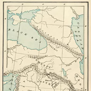
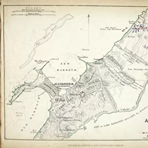
Map of Lower Egypt and part of Syria, published by William Blackwood and Sons

![]()
Wall Art and Photo Gifts from Fine Art Finder
Map of Lower Egypt and part of Syria, published by William Blackwood and Sons
746929 Map of Lower Egypt and part of Syria, published by William Blackwood and Sons, Edinburgh & London, 1848 (hand-coloured engraving) by Johnston, Alexander Keith (1804-71); Private Collection; (add.info.: Campaign of 1789-1801.); The Stapleton Collection; Scottish, out of copyright
Media ID 22397954
© The Stapleton Collection / Bridgeman Images
Aerial View Armies French Revolutionary Wars Mapping Nile Delta Positions Syria
FEATURES IN THESE COLLECTIONS
> Aerial Photography
> Related Images
> Aerial Photography
> Scotland
> Arts
> Artists
> A
> William Alexander
> Arts
> Artists
> K
> William Keith
> Arts
> Artists
> S
> Syrian Syrian
> Asia
> Syria
> Related Images
> Fine Art Finder
> Artists
> Alexander Keith Johnston
> Fine Art Finder
> Maps (celestial & Terrestrial)
EDITORS COMMENTS
This hand-coloured engraving, titled "Map of Lower Egypt and part of Syria" takes us back to the early 19th century during the French Revolutionary Wars. Published by William Blackwood and Sons in Edinburgh & London in 1848, this map offers a fascinating glimpse into the cartography and positions of armies during the campaign of 1789-1801. The aerial view depicted here showcases the coastal regions with intricate details along the shoreline, particularly highlighting the Nile Delta. As we examine this historical artifact, it becomes evident that meticulous effort was put into mapping out these strategic areas for military purposes. The significance of this map lies not only in its accurate representation but also in its ability to transport us back to a time when Egypt and Syria were at the center stage of conflict. It serves as a reminder of how geography played a crucial role in shaping history. As we delve deeper into this print from Alexander Keith Johnston's private collection, one cannot help but appreciate his mastery as a cartographer. The delicate engravings bring life to each contour line and symbolize an era where maritime exploration was paramount. While admiring this piece from Bridgeman Images' Fine Art Finder collection, let us reflect on how maps like these have shaped our understanding of past events while simultaneously igniting curiosity about those who once traversed these lands centuries ago.
MADE IN AUSTRALIA
Safe Shipping with 30 Day Money Back Guarantee
FREE PERSONALISATION*
We are proud to offer a range of customisation features including Personalised Captions, Color Filters and Picture Zoom Tools
SECURE PAYMENTS
We happily accept a wide range of payment options so you can pay for the things you need in the way that is most convenient for you
* Options may vary by product and licensing agreement. Zoomed Pictures can be adjusted in the Cart.