Home > Aerial Photography > France
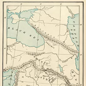
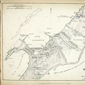
Map of the Siege of St. Jean d Acre, published by William Blackwood and Sons

![]()
Wall Art and Photo Gifts from Fine Art Finder
Map of the Siege of St. Jean d Acre, published by William Blackwood and Sons
746925 Map of the Siege of St. Jean d Acre, published by William Blackwood and Sons, Edinburgh & London, 1848 (hand-coloured engraving) by Johnston, Alexander Keith (1804-71); Private Collection; (add.info.: Siege of Acre (20 March - 21 May 1799)
); The Stapleton Collection; Scottish, out of copyright
Media ID 22397948
© The Stapleton Collection / Bridgeman Images
Aerial View Armies French Revolutionary Wars Mapping Ottoman Positions
FEATURES IN THESE COLLECTIONS
> Aerial Photography
> Related Images
> Aerial Photography
> Scotland
> Arts
> Artists
> A
> William Alexander
> Arts
> Artists
> K
> William Keith
> Arts
> Artists
> S
> Syrian Syrian
> Asia
> Syria
> Related Images
> Fine Art Finder
> Artists
> Alexander Keith Johnston
> Fine Art Finder
> Maps (celestial & Terrestrial)
EDITORS COMMENTS
This hand-coloured engraving, titled "Map of the Siege of St. Jean d Acre" takes us back to a significant moment in history - the French Revolutionary Wars and the French invasion of Egypt. Published by William Blackwood and Sons in 1848, this map provides a detailed aerial view of the siege that took place from March 20th to May 21st, 1799. The intricate cartography skillfully depicts the positions and movements of various armies involved in this historic conflict. The Ottoman forces defending St. Jean d'Acre are pitted against British troops supporting local resistance fighters, as well as French invaders seeking control over Egypt and Syria. As we examine this piece closely, it becomes evident that every element has been meticulously crafted by Alexander Keith Johnston. His expertise shines through in his ability to capture both strategic military details and geographical accuracy. This map not only serves as an invaluable historical document but also showcases the artistry behind cartography during the nineteenth century. The hand-colouring adds depth and vibrancy to each section, making it visually engaging for viewers even after centuries have passed since its creation. Preserved within a private collection today, this print allows us to delve into a crucial chapter in world history while appreciating the craftsmanship that went into producing such remarkable pieces of art.
MADE IN AUSTRALIA
Safe Shipping with 30 Day Money Back Guarantee
FREE PERSONALISATION*
We are proud to offer a range of customisation features including Personalised Captions, Color Filters and Picture Zoom Tools
SECURE PAYMENTS
We happily accept a wide range of payment options so you can pay for the things you need in the way that is most convenient for you
* Options may vary by product and licensing agreement. Zoomed Pictures can be adjusted in the Cart.