Home > Europe > France > Maps
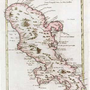
Martinique (overseas department or overseas department) - France and its Colonies. Atlas illustrates one hundred and five maps from the maps of the depot of war, bridges and footwear and the Navy by M. VUILLEMIN. 1876
 - France and its Colonies. Atlas illustrates one hundred and five maps from the maps of the depot of war, bridges and footwear and the Navy by M. VUILLEMIN. 1876")
![]()
Wall Art and Photo Gifts from Fine Art Finder
Martinique (overseas department or overseas department) - France and its Colonies. Atlas illustrates one hundred and five maps from the maps of the depot of war, bridges and footwear and the Navy by M. VUILLEMIN. 1876
XEE4144385 Martinique (overseas department or overseas department) - France and its Colonies. Atlas illustrates one hundred and five maps from the maps of the depot of war, bridges and footwear and the Navy by M. VUILLEMIN. 1876. by Vuillemin, Alexandre (1812-1886); Private Collection; (add.info.: Martinique (overseas department or overseas department) - France and its Colonies. Atlas illustrates one hundred and five maps from the maps of the depot of war, bridges and footwear and the Navy by M. VUILLEMIN. 1876.); Stefano Bianchetti; French, out of copyright
Media ID 25153678
© Stefano Bianchetti / Bridgeman Images
Atlas Book Caribbean Carribean City Map City Plan Dom Tom General Map Martinican Martinique Street Plan Geographical Map
FEATURES IN THESE COLLECTIONS
> Fine Art Finder
> Artists
> Alexandre Vuillemin
> Maps and Charts
> Related Images
> North America
> Martinique
> Maps
> North America
> Martinique
> Related Images
> Services
> Royal Navy
EDITORS COMMENTS
This print showcases a historical atlas titled "Martinique - France and its Colonies" from 1876. The atlas, created by M. Vuillemin, features an impressive collection of one hundred and five maps sourced from the depot of war, bridges and footwear, as well as the Navy. The image captures the essence of Martinique's significance within France's colonial empire during this era. The map itself provides a detailed geographical representation of Martinique, showcasing its position in the Caribbean region. It highlights various aspects such as cities, streets, and general topography with vibrant colors that bring it to life. Stefano Bianchetti has skillfully captured this engraving on behalf of a private collection. His expertise is evident in his ability to showcase every intricate detail while maintaining the authenticity and charm of the original work. This print not only serves as a visual delight but also offers valuable insights into Martinique's historical importance within French colonialism. It reminds us of how maps have played an essential role in documenting territories throughout history. Whether you are fascinated by geography or interested in exploring historical cartography, this remarkable piece will undoubtedly captivate your imagination and transport you back to 19th-century Martinique – a time when exploration was at its peak and new frontiers were being discovered.
MADE IN AUSTRALIA
Safe Shipping with 30 Day Money Back Guarantee
FREE PERSONALISATION*
We are proud to offer a range of customisation features including Personalised Captions, Color Filters and Picture Zoom Tools
SECURE PAYMENTS
We happily accept a wide range of payment options so you can pay for the things you need in the way that is most convenient for you
* Options may vary by product and licensing agreement. Zoomed Pictures can be adjusted in the Cart.