Home > Europe > United Kingdom > England > London > Museums > National Maritime Museum
Guatimala, 1685 (bound sheet)
")
![]()
Wall Art and Photo Gifts from Fine Art Finder
Guatimala, 1685 (bound sheet)
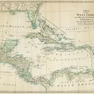
7339683 Guatimala, 1685 (bound sheet) by Hack, William (17th Century); 40x50 cm; National Maritime Museum, London, UK; (add.info.: Creator: William Hack
North America, the Pacific Coast, Guatemala and Volcan Acatenango. Bound in A Wagoner of the South Sea describing the sea coast from Acapulco to Albemarle isle, an English translation of a Spanish derrotero captured from the Spanish ship Rosario by Captain Bartholomew Sharpe in 1680. Hack made multiple copies of this atlas. This one was presented to James II. It shows Sharpe's track, depicts the silver mine at Potosi, has a decorated title cartouche and scale.); © National Maritime Museum, Greenwich, London
Media ID 38177044
© © National Maritime Museum, Greenwich, London / Bridgeman Images
Central America Coast Line Guatemala Guatimala Republic Of Guatemala
FEATURES IN THESE COLLECTIONS
> Arts
> Artists
> J
> William James
> Europe
> Spain
> Related Images
> Europe
> United Kingdom
> England
> London
> Boroughs
> Greenwich
> Europe
> United Kingdom
> England
> London
> Museums
> Greenwich Heritage Centre
> Europe
> United Kingdom
> England
> London
> Museums
> National Maritime Museum
> Europe
> United Kingdom
> England
> London
> Towns
> Greenwich
> Europe
> United Kingdom
> Heritage Sites
> Maritime Greenwich
> Europe
> United Kingdom
> Maps
> Fine Art Finder
> Artists
> Basil Ringrose
> Fine Art Finder
> Artists
> William Hack
EDITORS COMMENTS
This stunning print of Guatemala from 1685 captures the beauty and detail of William Hack's intricate map. The bound sheet showcases North America, the Pacific Coast, and Volcan Acatenango in exquisite detail. Created by Hack in the 17th century, this piece is a true work of art that has stood the test of time.
Bound in 'A Wagoner of the South Sea describing the sea coast from Acapulco to Albemarle Isle', an English translation captured from a Spanish derrotero by Captain Bartholomew Sharpe in 1680, this map is not only visually striking but also holds historical significance. Presented to James II, it shows Sharpe's track and depicts landmarks such as the silver mine at Potosi.
The vibrant colors and intricate details make this piece a captivating addition to any collection. From its decorative title cartouche to its scale indicator, every aspect of this map speaks to Hack's skill as a cartographer.
Whether you're a history buff or simply appreciate fine art, this print is sure to impress with its depiction of Central America's coastline and maritime features. Dive into the past with this remarkable piece from National Maritime Museum in London.
MADE IN AUSTRALIA
Safe Shipping with 30 Day Money Back Guarantee
FREE PERSONALISATION*
We are proud to offer a range of customisation features including Personalised Captions, Color Filters and Picture Zoom Tools
SECURE PAYMENTS
We happily accept a wide range of payment options so you can pay for the things you need in the way that is most convenient for you
* Options may vary by product and licensing agreement. Zoomed Pictures can be adjusted in the Cart.