Home > Europe > United Kingdom > England > London > Museums > National Maritime Museum
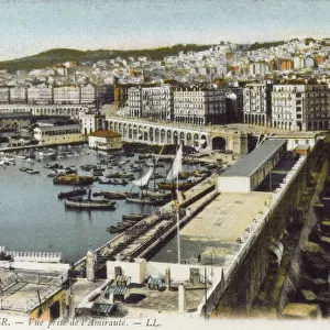
Chart of Algiers Bay, 1620 (ink on vellum)
")
![]()
Wall Art and Photo Gifts from Fine Art Finder
Chart of Algiers Bay, 1620 (ink on vellum)
7340488 Chart of Algiers Bay, 1620 (ink on vellum) by Norton, Robert (17th century); 58x49 cm; National Maritime Museum, London, UK; (add.info.: Creator: Robert Norton); © National Maritime Museum, Greenwich, London
Media ID 38177692
© © National Maritime Museum, Greenwich, London / Bridgeman Images
Algeria Algeria Algerian Algerian Algerians Algiers Arab Civilization Arab Culture Arabians Maghreb Maghrebi Maghrebian
FEATURES IN THESE COLLECTIONS
> Africa
> Algeria
> Related Images
> Africa
> Related Images
> Europe
> United Kingdom
> England
> London
> Boroughs
> Greenwich
> Europe
> United Kingdom
> England
> London
> Museums
> Greenwich Heritage Centre
> Europe
> United Kingdom
> England
> London
> Museums
> National Maritime Museum
> Europe
> United Kingdom
> England
> London
> Towns
> Greenwich
> Europe
> United Kingdom
> Heritage Sites
> Maritime Greenwich
> Europe
> United Kingdom
> Maps
> Fine Art Finder
> Artists
> British School
EDITORS COMMENTS
This stunning ink on vellum print of the Chart of Algiers Bay from 1620 by Robert Norton is a true masterpiece that captures the beauty and complexity of cartography in the 17th century. The intricate details and vibrant colors bring to life this historic map, showcasing Algiers, Algeria in all its glory.
The careful craftsmanship and attention to detail displayed in this work of art are truly remarkable. From the precise lines outlining the bay to the delicate shading that highlights different landmarks, every aspect of this map reflects Norton's skill as a cartographer.
As we gaze upon this piece, we are transported back in time to an era when maps were not just tools for navigation but works of art in their own right. The combination of artistic flair and scientific precision makes this chart a true testament to human ingenuity and creativity.
Through studying this map, we can gain insight into the Arab civilization that once thrived in North Africa, as well as appreciate the cultural richness and diversity of the region. It serves as a reminder of our shared history and interconnectedness with people from around the world.
Overall, this Chart of Algiers Bay is not just a visual delight but also a valuable historical artifact that deserves admiration for its beauty and significance.
MADE IN AUSTRALIA
Safe Shipping with 30 Day Money Back Guarantee
FREE PERSONALISATION*
We are proud to offer a range of customisation features including Personalised Captions, Color Filters and Picture Zoom Tools
SECURE PAYMENTS
We happily accept a wide range of payment options so you can pay for the things you need in the way that is most convenient for you
* Options may vary by product and licensing agreement. Zoomed Pictures can be adjusted in the Cart.