Home > Arts > Artists > O > Abraham Ortelius
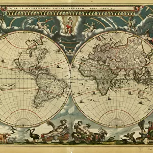
Map of the Mediterranean French odds (Galia Narbonense), 1570 (engraving)
, 1570 (engraving)")
![]()
Wall Art and Photo Gifts from Fine Art Finder
Map of the Mediterranean French odds (Galia Narbonense), 1570 (engraving)
AIS5366577 Map of the Mediterranean French odds (Galia Narbonense), 1570 (engraving); (add.info.: Strong water in colors, 1570, by Christophe Plantin (1514 or 1520-1589), Antwerp (Netherlands), in Theatrum Orbis Terrarum, 1570, by Abraham Ortelius (1527-1598). University Library of Salamanca (Spain).); © Iberfoto
Media ID 38374698
© © Iberfoto / Bridgeman Images
Mediterranean Sea Mediterrean Sea C16h Geographer Seawater
FEATURES IN THESE COLLECTIONS
> Arts
> Artists
> O
> Abraham Ortelius
> Europe
> France
> Sport
> Sailing
> Europe
> Netherlands
> Maps
> Europe
> Netherlands
> Posters
> Europe
> Netherlands
> Related Images
> Fine Art Finder
> Artists
> English School
> Maps and Charts
> Netherlands
EDITORS COMMENTS
This stunning engraving from 1570 depicts the Map of the Mediterranean French odds (Galia Narbonense) with intricate detail and vibrant colors. Created by Christophe Plantin in Antwerp, this map is a true masterpiece of cartography from the 16th century.
The rich history and significance of this map are evident in every line and color, showcasing the maritime routes and territories of the Mediterranean Sea during that time period. The careful attention to detail by Plantin highlights his skill as an engraver and geographer, capturing the essence of exploration and navigation in this era.
Displayed in Theatrum Orbis Terrarum by Abraham Ortelius, this map is a valuable piece housed at the University Library of Salamanca in Spain. It serves as a reminder of the importance of maps in understanding our world's geography and history.
As you gaze upon this print, you can almost feel yourself transported back to the 16th century, imagining ships sailing across these waters guided by maps like these. The colors pop off the page, drawing you into a world where exploration was at its peak and new discoveries were waiting around every corner.
This engraving is not just a map; it's a work of art that tells a story of adventure, discovery, and innovation.
MADE IN AUSTRALIA
Safe Shipping with 30 Day Money Back Guarantee
FREE PERSONALISATION*
We are proud to offer a range of customisation features including Personalised Captions, Color Filters and Picture Zoom Tools
SECURE PAYMENTS
We happily accept a wide range of payment options so you can pay for the things you need in the way that is most convenient for you
* Options may vary by product and licensing agreement. Zoomed Pictures can be adjusted in the Cart.