Home > Aerial Photography > France
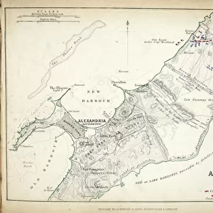
Map of the Siege of Toulon, published by William Blackwood and Sons, Edinburgh & London

![]()
Wall Art and Photo Gifts from Fine Art Finder
Map of the Siege of Toulon, published by William Blackwood and Sons, Edinburgh & London
746872 Map of the Siege of Toulon, published by William Blackwood and Sons, Edinburgh & London, 1848 (hand-coloured engraving) by Johnston, Alexander Keith (1804-71); Private Collection; (add.info.: Siege of Toulon (18 September-18 December 1793)); The Stapleton Collection; Scottish, out of copyright
Media ID 23484056
© The Stapleton Collection / Bridgeman Images
Aerial View Allies Armies French Revolutionary Wars Mapping Republicans Royalists
FEATURES IN THESE COLLECTIONS
> Aerial Photography
> Related Images
> Aerial Photography
> Scotland
> Arts
> Artists
> A
> William Alexander
> Arts
> Artists
> K
> William Keith
> Europe
> France
> Canton
> Allier
> Europe
> United Kingdom
> Scotland
> Aerial Views
> Fine Art Finder
> Artists
> Alexander Keith Johnston
> Fine Art Finder
> Artists
> English School
> Fine Art Finder
> Maps (celestial & Terrestrial)
EDITORS COMMENTS
This hand-coloured engraving, titled "Map of the Siege of Toulon" takes us back to a pivotal moment in history. Published by William Blackwood and Sons in Edinburgh & London in 1848, this print showcases the remarkable talent of Alexander Keith Johnston. The aerial view depicted here offers a bird's-eye perspective of the Siege of Toulon, which took place from September 18th to December 18th, 1793. The map provides an intricate layout of the city and its surroundings during this tumultuous time. It serves as a historical record that captures both military strategy and topographical details with precision. As we delve into this artwork, we witness the clash between two opposing forces: the French Republicans and Royalists. The fall of Toulon was a significant event during the French Revolutionary Wars, where various allies joined forces against Republican France. Johnston's meticulous craftsmanship brings life to this historical scene through his detailed engravings. Every stroke tells a story - from the positioning of armies on either side to their movements throughout the siege. This print not only serves as an invaluable resource for historians but also stands as a testament to Johnston's skill as a cartographer. Its inclusion in The Stapleton Collection further highlights its significance within Scottish art history. As we explore this intricately crafted map, we are transported back to one of Europe's most turbulent periods – an era defined by revolution and conflict.
MADE IN AUSTRALIA
Safe Shipping with 30 Day Money Back Guarantee
FREE PERSONALISATION*
We are proud to offer a range of customisation features including Personalised Captions, Color Filters and Picture Zoom Tools
SECURE PAYMENTS
We happily accept a wide range of payment options so you can pay for the things you need in the way that is most convenient for you
* Options may vary by product and licensing agreement. Zoomed Pictures can be adjusted in the Cart.