Home > Aerial Photography > Austria
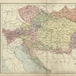
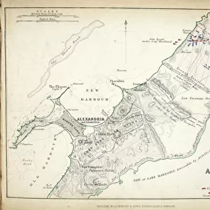
Map of the Battle of Hohenlinden, published by William Blackwood and Sons

![]()
Wall Art and Photo Gifts from Fine Art Finder
Map of the Battle of Hohenlinden, published by William Blackwood and Sons
746918 Map of the Battle of Hohenlinden, published by William Blackwood and Sons, Edinburgh & London, 1848 (hand-coloured engraving) by Johnston, Alexander Keith (1804-71); Private Collection; (add.info.: Battle of Hohenlinden (3 December 1800)); The Stapleton Collection; Scottish, out of copyright
Media ID 23165948
© The Stapleton Collection / Bridgeman Images
Aerial View Armies French Revolutionary Wars Mapping Positions War Of The Second Coalition
FEATURES IN THESE COLLECTIONS
> Aerial Photography
> Austria
> Aerial Photography
> Related Images
> Aerial Photography
> Scotland
> Arts
> Artists
> A
> William Alexander
> Arts
> Artists
> K
> William Keith
> Europe
> Austria
> Aerial Views
> Europe
> Austria
> Related Images
> Fine Art Finder
> Artists
> Alexander Keith Johnston
> Fine Art Finder
> Artists
> Francis G. O. Stuart
> Fine Art Finder
> Maps (celestial & Terrestrial)
EDITORS COMMENTS
This hand-coloured engraving, titled "Map of the Battle of Hohenlinden" takes us back to a significant moment in history. Published by William Blackwood and Sons in 1848, this print offers a detailed aerial view of the battlefield during the Battle of Hohenlinden on December 3rd, 1800. The map showcases the strategic positions held by both Austrian and French armies during the War of the Second Coalition. With meticulous cartography, Alexander Keith Johnston skillfully captures every contour and movement that shaped this historic clash. As we gaze upon this piece, we are transported to a time when nations clashed for power and dominance. The engraving not only serves as an invaluable historical document but also highlights the artistry involved in creating such intricate maps. The colours used to bring life to this print add depth and dimensionality to each element depicted. It is evident that great care was taken in ensuring accuracy while still capturing the essence of battle. With its rich detail and expert craftsmanship, this map invites us to explore one chapter from the French Revolutionary Wars. It reminds us how crucial mapping was for military strategists during these tumultuous times. Preserved within private collections today, this remarkable piece from The Stapleton Collection allows us a glimpse into an era long gone – an era defined by conflict, bravery, and ever-changing borders.
MADE IN AUSTRALIA
Safe Shipping with 30 Day Money Back Guarantee
FREE PERSONALISATION*
We are proud to offer a range of customisation features including Personalised Captions, Color Filters and Picture Zoom Tools
SECURE PAYMENTS
We happily accept a wide range of payment options so you can pay for the things you need in the way that is most convenient for you
* Options may vary by product and licensing agreement. Zoomed Pictures can be adjusted in the Cart.