Home > Africa > Libya > Maps
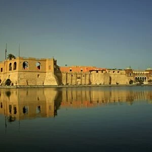
A map of the city and port of Tripoli in Barbary, 1675 (coloured engraving)
")
![]()
Wall Art and Photo Gifts from Fine Art Finder
A map of the city and port of Tripoli in Barbary, 1675 (coloured engraving)
7340047 A map of the city and port of Tripoli in Barbary, 1675 (coloured engraving) by Seller, John (1632-97); 42x53 cm; National Maritime Museum, London, UK; (add.info.: Creator: John Seller; Wenceslaus Hollar
South Central Mediterranean. A chart from Atlas Maritimus, or the Sea Atlas; being a book of maritime charts. It contains a key to the plan and a long inset view. The map is dedicated to the Duke of York and by John Seller who was Hydrographer to King Charles II.); © National Maritime Museum, Greenwich, London
Media ID 38515514
© © National Maritime Museum, Greenwich, London / Bridgeman Images
Boat Dock Harbor Area Harbour Area Harbours Libya Libyan Port Area Tripoli
FEATURES IN THESE COLLECTIONS
> Africa
> Libya
> Related Images
> Africa
> South Africa
> Maps
> Africa
> South Africa
> Related Images
> Arts
> Artists
> C
> King Charles
> Arts
> Artists
> H
> Wenceslaus Hollar
> Arts
> Artists
> S
> John Seller
> Europe
> United Kingdom
> England
> Herefordshire
> Ledbury
> Charles II
> Europe
> United Kingdom
> England
> London
> Boroughs
> Greenwich
> Fine Art Finder
> Artists
> John Seller
EDITORS COMMENTS
This stunning colored engraving from 1675 depicts a map of the city and port of Tripoli in Barbary, showcasing the intricate details of this historic North African location. Created by John Seller, who was Hydrographer to King Charles II, this piece is part of the 'Atlas Maritimus' or Sea Atlas and is dedicated to the Duke of York.
The map offers a glimpse into the South Central Mediterranean region during the 17th century, with a key to the plan and a long inset view included for reference. The vibrant colors bring life to the harbors, boats docks, and city streets depicted on this historical chart.
Tripoli's rich history as an important port city in Libya is beautifully captured in this artwork, providing valuable insight into its layout and surroundings during that time period. The detailed engravings showcase Seller's skill as an engraver and cartographer, offering viewers a window into the past.
This print from Fine Art Finder at the National Maritime Museum in London serves as both a decorative piece for any art lover and an educational tool for those interested in exploring historical maps. It stands as a testament to Seller's craftsmanship and dedication to accurately representing geographical locations through his work.
MADE IN AUSTRALIA
Safe Shipping with 30 Day Money Back Guarantee
FREE PERSONALISATION*
We are proud to offer a range of customisation features including Personalised Captions, Color Filters and Picture Zoom Tools
SECURE PAYMENTS
We happily accept a wide range of payment options so you can pay for the things you need in the way that is most convenient for you
* Options may vary by product and licensing agreement. Zoomed Pictures can be adjusted in the Cart.