Home > Europe > United Kingdom > England > London > Museums > National Maritime Museum
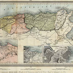
A general chart of the Atlantic Ocean north of the Equator, 1800 (engraving)
")
![]()
Wall Art and Photo Gifts from Fine Art Finder
A general chart of the Atlantic Ocean north of the Equator, 1800 (engraving)
7340458 A general chart of the Atlantic Ocean north of the Equator, 1800 (engraving) by Unknown Artist, (19th century); 58.5x89.5 cm; National Maritime Museum, London, UK; (add.info.: Creator: Deposito Hidrografico
Scale: 1:12 000 000. A graduated Mercator chart with the meridian through Cadiz and Atlantic Ocean north of the Equator.
Dedicated to Cornel, the Secretary of State for the Navy.); © National Maritime Museum, Greenwich, London
Media ID 38410202
© © National Maritime Museum, Greenwich, London / Bridgeman Images
Atlantic Atlantic Ocean Equator
FEATURES IN THESE COLLECTIONS
> Animals
> Insects
> Hemiptera
> Black Scale
> Europe
> United Kingdom
> England
> London
> Boroughs
> Greenwich
> Europe
> United Kingdom
> England
> London
> Museums
> Greenwich Heritage Centre
> Europe
> United Kingdom
> England
> London
> Museums
> National Maritime Museum
> Europe
> United Kingdom
> England
> London
> Towns
> Greenwich
> Europe
> United Kingdom
> Heritage Sites
> Maritime Greenwich
> Europe
> United Kingdom
> Maps
> Fine Art Finder
> Artists
> Unknown Artist
> Maps and Charts
> Early Maps
> Services
> Royal Navy
EDITORS COMMENTS
This stunning engraving from 1800 showcases a general chart of the Atlantic Ocean north of the Equator, offering a glimpse into the intricate world of cartography in the 19th century. Created by an unknown artist and measuring 58.5x89.5 cm, this detailed map was dedicated to Cornel, the Secretary of State for the Navy.
The engraving features a graduated Mercator chart with the meridian through Cadiz, providing valuable information about navigation and geography in that era. The scale is set at 1:12,000,000, allowing viewers to appreciate the vastness of the Atlantic Ocean and its surrounding areas.
Displayed at the National Maritime Museum in London, UK, this historical piece captures both artistry and scientific precision. The black-and-white aesthetic adds a classic touch to this depiction of one of Earth's largest bodies of water.
As we admire this engraving today, we are reminded of the dedication and expertise required to create such intricate maps without modern technology. It serves as a testament to human curiosity and exploration throughout history.
MADE IN AUSTRALIA
Safe Shipping with 30 Day Money Back Guarantee
FREE PERSONALISATION*
We are proud to offer a range of customisation features including Personalised Captions, Color Filters and Picture Zoom Tools
SECURE PAYMENTS
We happily accept a wide range of payment options so you can pay for the things you need in the way that is most convenient for you
* Options may vary by product and licensing agreement. Zoomed Pictures can be adjusted in the Cart.