Home > Europe > France > Canton > Nord
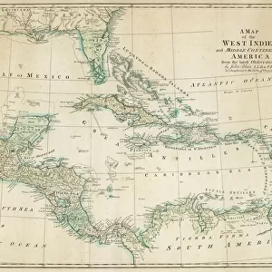
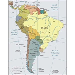
Geography Atlas: representation of the region of the Caribbean Sea, the Greater Antilles (Cuba, Jamaica, Hispaniola) and the small Antilles with colours indicating membership to France, Spain or Holland
 and the small Antilles with colours indicating membership to France, Spain or Holland")
![]()
Wall Art and Photo Gifts from Fine Art Finder
Geography Atlas: representation of the region of the Caribbean Sea, the Greater Antilles (Cuba, Jamaica, Hispaniola) and the small Antilles with colours indicating membership to France, Spain or Holland
VEN5030081 Geography Atlas: representation of the region of the Caribbean Sea, the Greater Antilles (Cuba, Jamaica, Hispaniola) and the small Antilles with colours indicating membership to France, Spain or Holland. Map from an Atlas by Jean Covens and Corneille Mortier, 1720. Biblioteca Jose Marti, Havana, Cuba.; (add.info.: Geography Atlas: representation of the region of the Caribbean Sea, the Greater Antilles (Cuba, Jamaica, Hispaniola) and the small Antilles with colours indicating membership to France, Spain or Holland. Map from an Atlas by Jean Covens and Corneille Mortier, 1720. Biblioteca Jose Marti, Havana, Cuba.); © Marage Photos
Media ID 38425742
© © Marage Photos / Bridgeman Images
Amerique Centrale Amerique Du Nord Caraïbes Caribbean Caribbean Island Carte Geographique Central America Colonialisme Cuba Cuba Cubain Cubaine Cubains Cubaines Cuban Etats Unis Geographie Jamaica Jamaican Stockravenna Geographical Map
FEATURES IN THESE COLLECTIONS
> Europe
> France
> Canton
> Nord
> Fine Art Finder
> Artists
> Pasquier (workshop of) Grenier
> Maps and Charts
> Related Images
> Maps and Charts
> Spain
> North America
> Cuba
> Cuba Heritage Sites
> Old Havana and its Fortification System
> North America
> Cuba
> Havana
EDITORS COMMENTS
This stunning print from a Geography Atlas showcases the intricate details of the region of the Caribbean Sea, highlighting the Greater Antilles such as Cuba, Jamaica, and Hispaniola, as well as the small Antilles. The use of colors to indicate membership to France, Spain, or Holland adds a visual element that brings this historical map to life.
Created by Jean Covens and Corneille Mortier in 1720, this map is a true work of art that provides insight into the colonial influences in the Caribbean during that time period. Displayed at Biblioteca Jose Marti in Havana, Cuba, this piece serves as a reminder of the complex history and cultural diversity of these islands.
From North America to Central America and beyond, this map captures not only geographical boundaries but also echoes of European colonialism. The engravings on this map showcase the craftsmanship and attention to detail that was put into creating such an important tool for understanding our world.
Whether you are a history buff or simply appreciate fine artistry, this Geography Atlas print is sure to captivate your imagination and transport you back in time to an era when exploration and discovery shaped our understanding of the world around us.
MADE IN AUSTRALIA
Safe Shipping with 30 Day Money Back Guarantee
FREE PERSONALISATION*
We are proud to offer a range of customisation features including Personalised Captions, Color Filters and Picture Zoom Tools
SECURE PAYMENTS
We happily accept a wide range of payment options so you can pay for the things you need in the way that is most convenient for you
* Options may vary by product and licensing agreement. Zoomed Pictures can be adjusted in the Cart.