Home > Europe > France > Canton > Nord
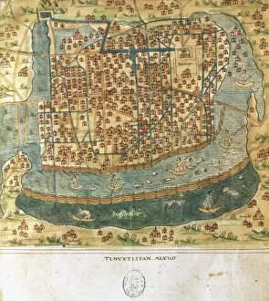
Geography: map of the islands of Central America (Antilles), the Detroit of Panama and representation of Mexico City. Plate from an Atlas by the French cartographer Jean-Baptiste Bourguignon d'Anville (1697-1782), 1731
, the Detroit of Panama and representation of Mexico City. Plate from an Atlas by the French cartographer Jean-Baptiste Bourguignon d'Anville (1697-1782), 1731")
![]()
Wall Art and Photo Gifts from Fine Art Finder
Geography: map of the islands of Central America (Antilles), the Detroit of Panama and representation of Mexico City. Plate from an Atlas by the French cartographer Jean-Baptiste Bourguignon d'Anville (1697-1782), 1731
VEN5031188 Geography: map of the islands of Central America (Antilles), the Detroit of Panama and representation of Mexico City. Plate from an Atlas by the French cartographer Jean-Baptiste Bourguignon d'Anville (1697-1782), 1731; (add.info.: Geography: map of the islands of Central America (Antilles), the Detroit of Panama and representation of Mexico City. Plate from an Atlas by the French cartographer Jean-Baptiste Bourguignon d'Anville (1697-1782), 1731); © Marage Photos
Media ID 38425762
© © Marage Photos / Bridgeman Images
Amerique Centrale Amerique Du Nord Caraïbes Caribbean Caribbean Island Carte Geographique Central America Etats Unis Geographie Mexicans Mexico Mexican Mexique Panama Stockravenna 18eme Siecle Geographical Map
FEATURES IN THESE COLLECTIONS
> Europe
> France
> Canton
> Nord
> Fine Art Finder
> Artists
> Pasquier (workshop of) Grenier
> Maps and Charts
> Early Maps
> Maps and Charts
> Related Images
> North America
> Mexico
> Maps
> North America
> Mexico
> Mexico City
> North America
> Mexico
> Related Images
> North America
> Panama
> Maps
EDITORS COMMENTS
This stunning print captures a detailed map of the islands of Central America (Antilles), the Detroit of Panama, and a representation of Mexico City. Created by the talented French cartographer Jean-Baptiste Bourguignon d'Anville in 1731, this plate from an Atlas showcases the intricate beauty of geography in the 18th century.
The map is filled with rich historical significance, providing a glimpse into the past and showcasing the vast landscapes and waterways that make up these regions. From the lush Caribbean islands to the bustling cityscape of Mexico City, each detail is meticulously illustrated with precision and artistry.
As you gaze upon this piece, you can't help but be transported back in time to an era where exploration and discovery were at their peak. The engraving captures not only the physical features of these areas but also hints at the cultural diversity and vibrant communities that call them home.
Whether you have a passion for history, geography, or simply appreciate fine art, this print is sure to captivate your imagination and inspire curiosity about these fascinating regions. Let it serve as a reminder of how interconnected our world truly is, bridging continents and cultures through maps like this one.
MADE IN AUSTRALIA
Safe Shipping with 30 Day Money Back Guarantee
FREE PERSONALISATION*
We are proud to offer a range of customisation features including Personalised Captions, Color Filters and Picture Zoom Tools
SECURE PAYMENTS
We happily accept a wide range of payment options so you can pay for the things you need in the way that is most convenient for you
* Options may vary by product and licensing agreement. Zoomed Pictures can be adjusted in the Cart.