Home > Maps and Charts > Americas
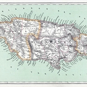
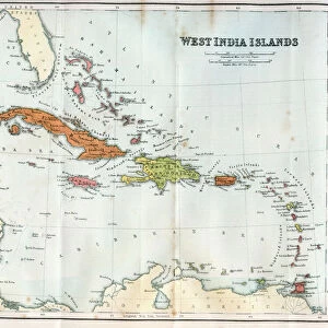
West Indies and the adjacent parts of North and South America, 1755

![]()
Wall Art and Photo Gifts from Fine Art Finder
West Indies and the adjacent parts of North and South America, 1755
2902872 West Indies and the adjacent parts of North and South America, 1755; (add.info.: West Indies and the adjacent parts of North and South America, 1755.); Buyenlarge Archive/UIG
Media ID 38152454
© Buyenlarge Archive/UIG / Bridgeman Images
1750s Bahamas Caribbean Carribean Cartographic Hispaniola Indies Islands Jamaica Puerto Rico Virgin Islands
FEATURES IN THESE COLLECTIONS
> Fine Art Finder
> Artists
> Raymond de la Neziere
> Maps and Charts
> Related Images
> North America
> The Bahamas
> Maps
> North America
> The Bahamas
> Related Images
> North America
> Jamaica
> Maps
> North America
> Jamaica
> Related Images
> North America
> Mexico
> Maps
> North America
> Mexico
> Related Images
> North America
> Puerto Rico
> Maps
> North America
> Puerto Rico
> Related Images
EDITORS COMMENTS
This stunning print captures the intricate and detailed map of the West Indies and adjacent parts of North and South America from 1755. The map, created in the midst of colonial expansion and conflict, showcases the vast expanse of islands, including the Bahamas, Jamaica, Puerto Rico, Hispaniola, and the Virgin Islands.
The cartographic masterpiece provides a window into a pivotal moment in history when European powers were vying for control over territories in the Americas. The strategic importance of these islands is evident as they served as crucial trading posts and military outposts during this time.
The vibrant colors and meticulous attention to detail highlight the artistry involved in creating such maps during the 18th century. Each line and symbol on this map tells a story of exploration, conquest, and cultural exchange that shaped the landscape we see today.
As we gaze upon this historical artifact, we are reminded of the complex tapestry of connections between nations across continents. This image serves as a reminder of our shared past and invites us to reflect on how these interactions continue to influence our world today.
Overall, this print is not just a visual representation but also a gateway to understanding the rich history behind these lands that have witnessed centuries of change and transformation.
MADE IN AUSTRALIA
Safe Shipping with 30 Day Money Back Guarantee
FREE PERSONALISATION*
We are proud to offer a range of customisation features including Personalised Captions, Color Filters and Picture Zoom Tools
SECURE PAYMENTS
We happily accept a wide range of payment options so you can pay for the things you need in the way that is most convenient for you
* Options may vary by product and licensing agreement. Zoomed Pictures can be adjusted in the Cart.