Home > Animals > Fishes > E > European Perch
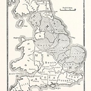
Sheet 16 from: An exact survey of the cities of London and Westminster, the Borough of Southwark, with the country near ten miles round... 1746 (coloured engraving)
")
![]()
Wall Art and Photo Gifts from Fine Art Finder
Sheet 16 from: An exact survey of the cities of London and Westminster, the Borough of Southwark, with the country near ten miles round... 1746 (coloured engraving)
7340520 Sheet 16 from: An exact survey of the cities of London and Westminster, the Borough of Southwark, with the country near ten miles round... 1746 (coloured engraving) by Rocque, John (c.1704-d.1762); 51x67 cm; National Maritime Museum, London, UK; (add.info.: Creator: John Rocque
Bound sheet. Hand col. engr. Scale: ca. 1:12 370 (bar). Cartographic Note: The map has bar scales in miles, furlongs and perches on sheet 1; in feet, chains and yards on sheet 9, and in woerst de Moscovie, French leagues and toises, and Swedish Danish and Swiss leagues on sheet 16. Additional Places: Hampton Court, Kingston, Norbiton.
Sheet x1, y1 of a sixteen sheet map. John Rocque came to England as a child with his French Huguenot family. He was an estate surveyor and garden designer before he began mapping towns.); © National Maritime Museum, Greenwich, London
Media ID 38519444
© © National Maritime Museum, Greenwich, London / Bridgeman Images
Hampton Court Hampton Court Palace Hampton Court Park
FEATURES IN THESE COLLECTIONS
> Animals
> Fishes
> E
> European Perch
> Animals
> Fishes
> P
> Perch
> Animals
> Insects
> Spiders
> European Garden
> Arts
> Artists
> R
> John Rocque
> Europe
> Denmark
> Related Images
> Europe
> Republic of Ireland
> Maps
> Fine Art Finder
> Artists
> John Rocque
> Fine Art Finder
> Artists
> Thomas Jefferys
EDITORS COMMENTS
This beautifully detailed coloured engraving, Sheet 16 from John Rocque's "An exact survey of the cities of London and Westminster, the Borough of Southwark, with the country near ten miles round..." provides a fascinating glimpse into 18th century London. Measuring 51x67 cm, this map is part of a larger sixteen sheet series that showcases Rocque's meticulous cartographic skills.
John Rocque, a French Huguenot immigrant to England, was not only an estate surveyor and garden designer but also a talented mapmaker. His attention to detail is evident in this map, which includes bar scales in various units such as miles, furlongs, perches, feet, chains and yards.
Sheet 16 features locations such as Hampton Court, Kingston and Norbiton within its boundaries. The intricate design and historical significance make this print a valuable piece for anyone interested in the history of London.
Displayed at the National Maritime Museum in Greenwich, London; this print captures the essence of Rocque's work and his contribution to mapping towns during his time. It serves as a reminder of the rich heritage and architectural landscape that once existed in one of the world's most iconic cities.
MADE IN AUSTRALIA
Safe Shipping with 30 Day Money Back Guarantee
FREE PERSONALISATION*
We are proud to offer a range of customisation features including Personalised Captions, Color Filters and Picture Zoom Tools
SECURE PAYMENTS
We happily accept a wide range of payment options so you can pay for the things you need in the way that is most convenient for you
* Options may vary by product and licensing agreement. Zoomed Pictures can be adjusted in the Cart.