Home > Africa > Morocco > Maps
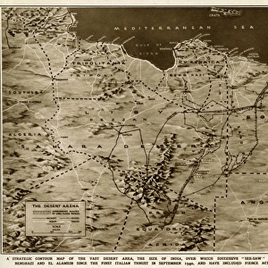
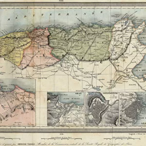
Geographic atlas: detail of the portulan of Francois Ollive representing Barbarie (Algeria, Tunisia, Tripolitan) and Morocco. 1661 Municipal Library of Marseille
 and Morocco. 1661 Municipal Library of Marseille")
![]()
Wall Art and Photo Gifts from Fine Art Finder
Geographic atlas: detail of the portulan of Francois Ollive representing Barbarie (Algeria, Tunisia, Tripolitan) and Morocco. 1661 Municipal Library of Marseille
JEB4874959 Geographic atlas: detail of the portulan of Francois Ollive representing Barbarie (Algeria, Tunisia, Tripolitan) and Morocco. 1661 Municipal Library of Marseille.; (add.info.: Geographic atlas: detail of the portulan of Francois Ollive representing Barbarie (Algeria, Tunisia, Tripolitan) and Morocco. 1661 Municipal Library of Marseille.); © Jean Bernard. All rights reserved 2023
Media ID 38426996
© © Jean Bernard. All rights reserved 2024 / Bridgeman Images
Algeria Algeria Algerian Algerian Algerians Algerie Arab Country Maghrebin Maghrebine Mediterranean Sea Moroccan Morocco North African Tunisia Tunisian 17th Centuries Africa African African Arab Civilization Arab Culture Arabians Geographical Map Jeanbernard Maghreb Maghrebi Maghrebian
FEATURES IN THESE COLLECTIONS
> Africa
> Algeria
> Related Images
> Africa
> Morocco
> Related Images
> Africa
> Tunisia
> Related Images
> Fine Art Finder
> Artists
> Unknown Artist
> Maps and Charts
> Early Maps
> Maps and Charts
> Related Images
EDITORS COMMENTS
This stunning print captures the intricate detail of a portulan map created by Francois Ollive in 1661, showcasing the regions of Barbarie (Algeria, Tunisia, Tripolitan) and Morocco. The Municipal Library of Marseille houses this historical piece, offering a glimpse into the geographical knowledge and cartographic skills of the 17th century.
The map provides a fascinating look at North Africa during this time period, highlighting the coastal areas along the Mediterranean Sea. From Algeria to Tunisia and Tripolitania to Morocco, each region is meticulously depicted with precision and artistry.
As we study this portulan map, we are transported back in time to an era when exploration and discovery were at the forefront of human curiosity. The vibrant colors and intricate patterns draw us in, inviting us to explore these exotic lands through the eyes of early cartographers like Ollive.
Through this print by Jean Bernard, we not only appreciate the beauty of this historical artifact but also gain a deeper understanding of the rich cultural heritage and diverse landscapes that make up North Africa. It serves as a reminder of how interconnected our world has always been, even centuries ago.
MADE IN AUSTRALIA
Safe Shipping with 30 Day Money Back Guarantee
FREE PERSONALISATION*
We are proud to offer a range of customisation features including Personalised Captions, Color Filters and Picture Zoom Tools
SECURE PAYMENTS
We happily accept a wide range of payment options so you can pay for the things you need in the way that is most convenient for you
* Options may vary by product and licensing agreement. Zoomed Pictures can be adjusted in the Cart.