Home > North America > Haiti > Maps
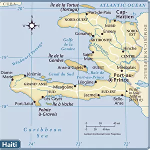
Map of the island of Hispaniola (Santo Domingo or Haiti), Caribbean Sea, circa 1870 - Lithograph 19th century (Map of Hispaniola, including Haiti and Santo Domingo, 1870s, Color lithograph)
, Caribbean Sea, circa 1870 - Lithograph 19th century (Map of Hispaniola, including Haiti and Santo Domingo, 1870s, Color lithograph)")
![]()
Wall Art and Photo Gifts from Fine Art Finder
Map of the island of Hispaniola (Santo Domingo or Haiti), Caribbean Sea, circa 1870 - Lithograph 19th century (Map of Hispaniola, including Haiti and Santo Domingo, 1870s, Color lithograph)
NWI4866878 Map of the island of Hispaniola (Santo Domingo or Haiti), Caribbean Sea, circa 1870 - Lithograph 19th century (Map of Hispaniola, including Haiti and Santo Domingo, 1870s, Color lithograph); (add.info.: Map of the island of Hispaniola (Santo Domingo or Haiti), Caribbean Sea, circa 1870 - Lithograph 19th century (Map of Hispaniola, including Haiti and Santo Domingo, 1870s, Color lithograph)); Photo © North Wind Pictures
Media ID 38426660
© © North Wind Pictures / Bridgeman Images
Caribbean Caribbean Island Dominium Haiti Geographical Map
FEATURES IN THESE COLLECTIONS
> Fine Art Finder
> Artists
> Unknown Artist
> Maps and Charts
> Early Maps
> Maps and Charts
> Related Images
> North America
> Haiti
> Maps
> North America
> Haiti
> Related Images
> Popular Themes
> North Island
EDITORS COMMENTS
This stunning lithograph print from the 19th century showcases a detailed map of the island of Hispaniola, encompassing both Haiti and Santo Domingo in the Caribbean Sea. The intricate color lithograph captures the geographical features of the island with precision, offering a glimpse into its topography and layout during this time period.
The map provides a historical perspective on the division of land between Haiti and Santo Domingo, highlighting borders and boundaries that have evolved over centuries. It serves as a valuable tool for understanding the geography and political landscape of this region in the 1870s.
With vibrant colors and intricate details, this lithograph is not only visually captivating but also informative. It offers viewers a chance to explore the nuances of cartography in the 19th century, showcasing advancements in printing technology and artistic skill.
Whether you are an avid collector of antique maps or simply appreciate historical artwork, this print is sure to captivate your imagination. Transport yourself back in time to an era when exploration and discovery were at their peak with this exquisite depiction of Hispaniola.
MADE IN AUSTRALIA
Safe Shipping with 30 Day Money Back Guarantee
FREE PERSONALISATION*
We are proud to offer a range of customisation features including Personalised Captions, Color Filters and Picture Zoom Tools
SECURE PAYMENTS
We happily accept a wide range of payment options so you can pay for the things you need in the way that is most convenient for you
* Options may vary by product and licensing agreement. Zoomed Pictures can be adjusted in the Cart.