Home > Historic > Ancient civilizations > Ancient Greece > Greek history
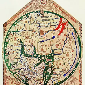
World map of Claude Ptolemee (Claudius Ptolemaeus, 90-168) illustrating the flat earth. Colourful engraving of the 19th century
 illustrating the flat earth. Colourful engraving of the 19th century")
![]()
Wall Art and Photo Gifts from Fine Art Finder
World map of Claude Ptolemee (Claudius Ptolemaeus, 90-168) illustrating the flat earth. Colourful engraving of the 19th century
NWI4846095 World map of Claude Ptolemee (Claudius Ptolemaeus, 90-168) illustrating the flat earth. Colourful engraving of the 19th century.; (add.info.: World map of Claude Ptolemee (Claudius Ptolemaeus, 90-168) illustrating the flat earth. Colourful engraving of the 19th century.); Photo © North Wind Pictures
Media ID 38271144
© © North Wind Pictures / Bridgeman Images
2 2nd 2nd 2nd Ii Iird Century 2 2nd Ii Iind Century 2 Century 2nd Century 2nd Century Ad Ancient Greeks Astrologer Astronomer Astronomers C2nd Claudius Ptolemaeus Claudius Ptolemy Ii Century Iind Century Planisphere Ptolemy Second Century Second Century Ad Antique Greece Geographical Map Grece Greece Greek
FEATURES IN THESE COLLECTIONS
> Europe
> Greece
> Related Images
> Fine Art Finder
> Artists
> Unknown photographer
> Historic
> Ancient civilizations
> Ancient Greece
> Greek history
> Maps and Charts
> Early Maps
> Maps and Charts
> Flat Earth
> Maps and Charts
> Related Images
> Maps and Charts
> World
EDITORS COMMENTS
This vibrant and detailed print captures a World map of Claude Ptolemee, also known as Claudius Ptolemaeus, from the 19th century. The colourful engraving illustrates the concept of a flat earth as believed by ancient civilizations such as the Greeks.
Claudius Ptolemaeus, who lived in the 2nd century AD, was a renowned astronomer and mathematician whose work had a significant impact on our understanding of the universe. His geocentric model of the universe placed Earth at the center with all celestial bodies revolving around it.
The intricate details and rich colors of this engraving bring to life Ptolemy's vision of the world during antiquity. From Europe to Greece, every region is meticulously depicted on this historical map.
As we gaze upon this piece of art, we are transported back in time to an era where knowledge and exploration were at their peak. It serves as a reminder of how far we have come in our understanding of geography and astronomy since Ptolemy's time.
This print is not just a visual representation but also a testament to human curiosity and ingenuity throughout history. It is a fascinating glimpse into our past that continues to inspire awe and wonder in viewers today.
MADE IN AUSTRALIA
Safe Shipping with 30 Day Money Back Guarantee
FREE PERSONALISATION*
We are proud to offer a range of customisation features including Personalised Captions, Color Filters and Picture Zoom Tools
SECURE PAYMENTS
We happily accept a wide range of payment options so you can pay for the things you need in the way that is most convenient for you
* Options may vary by product and licensing agreement. Zoomed Pictures can be adjusted in the Cart.