Home > Europe > United Kingdom > England > London > Sport > Sailing
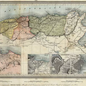
Adriatic chart, c.1620 (vellum)
")
![]()
Wall Art and Photo Gifts from Fine Art Finder
Adriatic chart, c.1620 (vellum)
7339786 Adriatic chart, c.1620 (vellum) by Unknown Artist, (17th century); 41x60 cm; National Maritime Museum, London, UK; (add.info.: Creator: unknown
This type of early vellum sea chart originated in the Mediterranean in the 13th century. They are often referred to as Portulan or Portolan charts, a name taken from the written sailing directions, portolani, which they supplemented and superseded, although this attribution is not always technically correct. They were drawn in coloured ink on vellum.); © National Maritime Museum, Greenwich, London
Media ID 38288574
© © National Maritime Museum, Greenwich, London / Bridgeman Images
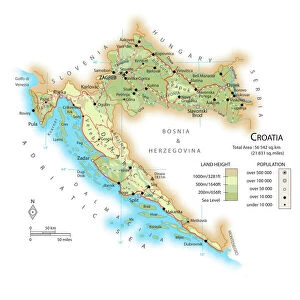
Croatia Croatian Croatians Mediterranea Mediterranean Mediterranean Sea Mediterrean Mediterrean Sea Meditteranean
FEATURES IN THESE COLLECTIONS
> Europe
> Croatia
> Related Images
> Europe
> France
> Sport
> Sailing
> Europe
> United Kingdom
> England
> London
> Boroughs
> Greenwich
> Europe
> United Kingdom
> England
> London
> Museums
> Greenwich Heritage Centre
> Europe
> United Kingdom
> England
> London
> Museums
> National Maritime Museum
> Europe
> United Kingdom
> England
> London
> Sport
> Sailing
> Fine Art Finder
> Artists
> Unknown Artist
> Fine Art Finder
> Artists
> William Hack
EDITORS COMMENTS
This stunning print captures an Adriatic chart dating back to around 1620, created by an unknown artist in the 17th century. The intricate details and vibrant colors of this vellum sea chart showcase the skill and artistry of early cartographers.
Originating in the Mediterranean in the 13th century, these types of charts were known as 'Portulan' or 'Portolan' charts, named after the written sailing directions they supplemented. Drawn with colored ink on vellum, these charts were essential tools for sailors navigating the seas.
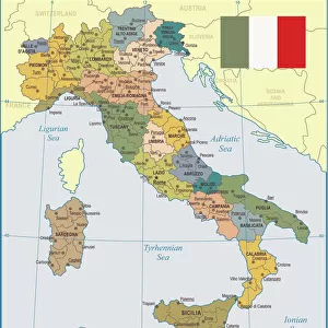
The map covers a region including Italy, France, Croatia, and other parts of Europe bordering the Mediterranean Sea. It provides a glimpse into maritime history and navigation techniques used during that time period.
The careful craftsmanship displayed in this piece reflects both practicality and beauty. Each line and symbol serves a purpose in guiding ships through treacherous waters while also creating a visually appealing work of art.
This print from Bridgeman Images allows us to appreciate not only the historical significance of this Adriatic chart but also its artistic value as a masterpiece from centuries past.
MADE IN AUSTRALIA
Safe Shipping with 30 Day Money Back Guarantee
FREE PERSONALISATION*
We are proud to offer a range of customisation features including Personalised Captions, Color Filters and Picture Zoom Tools
SECURE PAYMENTS
We happily accept a wide range of payment options so you can pay for the things you need in the way that is most convenient for you
* Options may vary by product and licensing agreement. Zoomed Pictures can be adjusted in the Cart.