Home > Europe > United Kingdom > England > London > Museums > National Maritime Museum
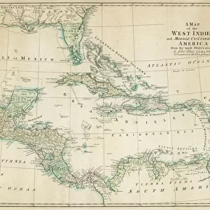
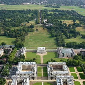
The Bay of Phillipina, 1685 (bound sheet)
")
![]()
Wall Art and Photo Gifts from Fine Art Finder
The Bay of Phillipina, 1685 (bound sheet)
7339705 The Bay of Phillipina, 1685 (bound sheet) by Hack, William (17th Century); 40x50 cm; National Maritime Museum, London, UK; (add.info.: Creator: William Hack
North America, the Pacific Coast, Panama, Isla Cebaco and Rio de Jesus. Bound in A Wagoner of the South Sea describing the sea coast from Acapulco to Albemarle isle, an English translation of a Spanish derrotero captured from the Spanish ship Rosario by Captain Bartholomew Sharpe in 1680. Hack made multiple copies of this atlas. This one was presented to James II. It shows Sharpe's track, depicts the silver mine at Potosi, has a decorated title cartouche and scale.); © National Maritime Museum, Greenwich, London
Media ID 38510016
© © National Maritime Museum, Greenwich, London / Bridgeman Images
Central America Coast Line Panama Panamian Panamians
FEATURES IN THESE COLLECTIONS
> Arts
> Artists
> B
> James Bayes
> Arts
> Artists
> J
> William James
> Europe
> United Kingdom
> England
> London
> Boroughs
> Greenwich
> Europe
> United Kingdom
> England
> London
> Museums
> Greenwich Heritage Centre
> Europe
> United Kingdom
> England
> London
> Museums
> National Maritime Museum
> Europe
> United Kingdom
> England
> London
> Towns
> Greenwich
> Europe
> United Kingdom
> Heritage Sites
> Maritime Greenwich
> Europe
> United Kingdom
> Maps
> Fine Art Finder
> Artists
> William Hack
EDITORS COMMENTS
This stunning print of The Bay of Phillipina, 1685 by William Hack transports us back to the 17th century, offering a glimpse into the intricate world of cartography during this time. The detailed depiction of North America's Pacific Coast, Panama, Isla Cebaco and Rio de Jesus is not only visually captivating but also historically significant.
Bound in 'A Wagoner of the South Sea', an English translation captured from a Spanish derrotero by Captain Bartholomew Sharpe in 1680, this print showcases Hack's skillful craftsmanship and attention to detail. Presented to James II, it serves as a testament to the importance of maritime exploration and navigation during this era.
The vibrant colors and elaborate design elements such as the decorated title cartouche and scale add an artistic flair to this map, making it not just a practical tool for navigation but also a work of art in its own right. As we gaze upon this piece from the National Maritime Museum in London, we are reminded of the rich history and cultural significance embedded within each stroke of Hack's pen.
This print is more than just a representation of geographical locations; it is a window into the past that allows us to appreciate both the beauty and complexity of early cartographic works.
MADE IN AUSTRALIA
Safe Shipping with 30 Day Money Back Guarantee
FREE PERSONALISATION*
We are proud to offer a range of customisation features including Personalised Captions, Color Filters and Picture Zoom Tools
SECURE PAYMENTS
We happily accept a wide range of payment options so you can pay for the things you need in the way that is most convenient for you
* Options may vary by product and licensing agreement. Zoomed Pictures can be adjusted in the Cart.