Home > Europe > United Kingdom > England > London > Museums > National Maritime Museum
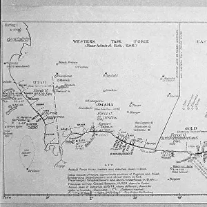
Chart of the Mediterrean, Black and Caspian Seas, c.1600 (manuscript)
")
![]()
Wall Art and Photo Gifts from Fine Art Finder
Chart of the Mediterrean, Black and Caspian Seas, c.1600 (manuscript)
7339791 Chart of the Mediterrean, Black and Caspian Seas, c.1600 (manuscript) by Unknown Artist, (17th century); 47x35 cm; National Maritime Museum, London, UK; (add.info.: Creator: unknown
Bound in an atlas of six charts. French, highly decorated, unsigned and undated.); © National Maritime Museum, Greenwich, London
Media ID 38177072
© © National Maritime Museum, Greenwich, London / Bridgeman Images
Black Sea Mediterranea Mediterranean Mediterranean Sea Mediterrean Mediterrean Sea Meditteranean
FEATURES IN THESE COLLECTIONS
> Europe
> United Kingdom
> England
> London
> Boroughs
> Greenwich
> Europe
> United Kingdom
> England
> London
> Museums
> Greenwich Heritage Centre
> Europe
> United Kingdom
> England
> London
> Museums
> National Maritime Museum
> Europe
> United Kingdom
> England
> London
> Towns
> Greenwich
> Europe
> United Kingdom
> Heritage Sites
> Maritime Greenwich
> Europe
> United Kingdom
> Maps
> Fine Art Finder
> Artists
> Unknown Artist
> Fine Art Finder
> Artists
> William Hack
> Maps and Charts
> Early Maps
> Maps and Charts
> Related Images
EDITORS COMMENTS
This stunning manuscript print of the Chart of the Mediterranean, Black and Caspian Seas from around 1600 is a true masterpiece of cartography. The intricate details and vibrant colors bring to life the vast expanse of these important bodies of water in Europe.
Created by an unknown artist in the 17th century, this chart is part of an atlas containing six charts that showcase French craftsmanship at its finest. The meticulous attention to detail and decorative elements make this piece a true work of art.
The National Maritime Museum in London houses this historical treasure, allowing visitors to marvel at the skill and expertise that went into creating such a detailed map. From the coastlines to the intricate patterns on land, every aspect has been carefully considered and beautifully rendered.
As you gaze upon this print, you can almost feel yourself transported back in time to when sailors relied on maps like these for navigation across treacherous waters. The combination of beauty and functionality makes this chart a valuable piece for historians and art enthusiasts alike.
Whether you are drawn to its historical significance or simply appreciate its aesthetic appeal, this Chart of the Mediterranean, Black and Caspian Seas is sure to captivate all who behold it.
MADE IN AUSTRALIA
Safe Shipping with 30 Day Money Back Guarantee
FREE PERSONALISATION*
We are proud to offer a range of customisation features including Personalised Captions, Color Filters and Picture Zoom Tools
SECURE PAYMENTS
We happily accept a wide range of payment options so you can pay for the things you need in the way that is most convenient for you
* Options may vary by product and licensing agreement. Zoomed Pictures can be adjusted in the Cart.