
Columbia River Collection
The majestic Columbia River flows through the Pacific Northwest, connecting two states and offering a rich tapestry of history and natural beauty


All Professionally Made to Order for Quick Shipping
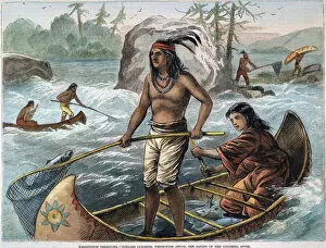
The majestic Columbia River flows through the Pacific Northwest, connecting two states and offering a rich tapestry of history and natural beauty. One iconic sight along this mighty river is the Astoria-Megler truss bridge, spanning across from Astoria, Oregon to Washington. This engineering marvel not only serves as a vital transportation link but also provides breathtaking views of the Columbia River. For centuries, Native Americans have had a deep connection with the river. In 1871, a wood engraving captured their fishing prowess as they caught whitefish in the rapids of the Washington Territory section of the Columbia River. The image showcases their skill and reliance on these waters for sustenance. Campgrounds along the they have long been home to Native American fishermen who set up temporary settlements during fishing seasons. These campsites are not just places to catch fish but also cultural hubs where traditions are passed down through generations. Moving downstream towards Cape Disappointment State Park in Washington State, you'll find North Head Lighthouse perched atop towering cliffs overlooking the river. Its beacon has guided countless ships navigating these treacherous waters over time. As you venture further south into Oregon's Astoria region, you'll encounter an enchanting scene where yachts dock at marinas while overlooking the magnificent Astoria Bridge stretching across the Columbia River. Nearby stands Cannery Pier Hotel - a charming reminder of Astoria's historic ties to its thriving fishing industry. Speaking of which, remnants of old fish canneries still dot parts of this riverside landscape – silent witnesses to bygone eras when salmon runs were abundant and canning factories buzzed with activity. Crossing borders into Canada's British Columbia reveals yet another captivating sight: a rainbow arching above Cache Creek tributary that feeds into Lake Revelstoke. Nature's vibrant display adds even more allure to this already picturesque setting. Heading back southbound in Oregon’s Columbia Gorge area brings us face to face with conifers standing tall on bluffs above Oneonta Gorge.