Home > Africa > Madagascar > Maps
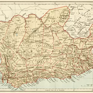
L'Imerina; Iles Africaines de la mer des Indes, 1914. Creator: Unknown

![]()
Wall Art and Photo Gifts from Heritage Images
L'Imerina; Iles Africaines de la mer des Indes, 1914. Creator: Unknown
L'Imerina; Iles Africaines de la mer des Indes, 1914. From "Grande Geographie Bong Illustree", 1914
Heritage Images features heritage image collections
Media ID 36297031
© The Print Collector/Heritage Images
Cartography Geological Map Madagascar Map Making Mapmaking
FEATURES IN THESE COLLECTIONS
> Africa
> Madagascar
> Maps
> Africa
> Madagascar
> Related Images
> Maps and Charts
> Geological Map
> Maps and Charts
> Related Images
EDITORS COMMENTS
L'Imerina: Iles Africaines de la Mer des Indes," a captivating and intricately detailed geographical map print from the early 20th century, offers a glimpse into the rich cartographic history of Madagascar and the African islands in the Indian Ocean. Created in 1914, this map is an exquisite example of the meticulous work that went into producing geographical maps during this era. The map, published in "Grande Geographie Bong Illustree," showcases the African islands in the Indian Ocean, with Madagascar occupying the central position. The vibrant colors and bold lines used in the map bring the various geographical features to life, making it an engaging visual representation of the region. The map is a testament to the advancements in cartography during the 1900s, as it includes not only the major islands but also smaller ones, as well as intricate details such as coastlines, depth contours, and topographical features. The map also includes labels for various locations, making it an essential tool for navigators and explorers of the time. The map's creation reflects the French colonial influence in the region, with the map's title and some labels written in French. The map's production also highlights the growing interest in geographical exploration and the desire to accurately map the world during the 20th century. Today, this map serves as an important historical document, providing valuable insights into the geographical knowledge of the African islands in the Indian Ocean during the early 1900s. Its intricate details and beautiful design make it a fascinating addition to any collection of historical maps or Africana.
MADE IN AUSTRALIA
Safe Shipping with 30 Day Money Back Guarantee
FREE PERSONALISATION*
We are proud to offer a range of customisation features including Personalised Captions, Color Filters and Picture Zoom Tools
SECURE PAYMENTS
We happily accept a wide range of payment options so you can pay for the things you need in the way that is most convenient for you
* Options may vary by product and licensing agreement. Zoomed Pictures can be adjusted in the Cart.