Home > Asia > Turkey > Istanbul
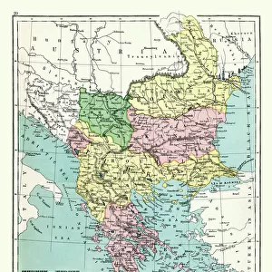
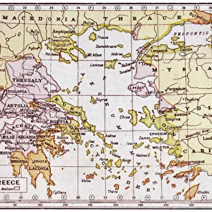
Map of the Balkan Peninsula, 1902. Creator: Unknown

![]()
Wall Art and Photo Gifts from Heritage Images
Map of the Balkan Peninsula, 1902. Creator: Unknown
Map of the Balkan Peninsula, 1902. Showing Bosnia, Servia (Serbia), Romania, Bulgaria, and Turkish-occupied Greece, with inset of Constantinople (Istanbul). From The Century Atlas of the World. [John Walker & Co, Ltd. London, 1902]
Heritage Images features heritage image collections
Media ID 15512212
© The Print Collector / Heritage-Images
Adriatic Sea Aegean Sea Balkans Bosnia Bulgaria Coastline Constantinople Crete Edinburgh Geographical Institute Island Islands Istanbul Marmara Peninsula Romania Scutari Serbia Stamboul Turkey Uskudar Balkan Peninsula
FEATURES IN THESE COLLECTIONS
> Asia
> Turkey
> Related Images
> Europe
> Bosnia and Herzegovina
> Maps
> Europe
> Bulgaria
> Related Images
> Europe
> Greece
> Related Images
EDITORS COMMENTS
This print showcases a detailed map of the Balkan Peninsula, dating back to 1902. Created by an unknown cartographer and featured in The Century Atlas of the World, this historical piece offers a glimpse into the geopolitical landscape of that era. The map encompasses several countries including Bosnia, Servia (Serbia), Romania, Bulgaria, and Turkish-occupied Greece. It also highlights significant geographical features such as the Adriatic Sea, Aegean Sea, Marmara Sea, and various islands like Crete. The inclusion of an inset featuring Constantinople (now Istanbul) adds further depth to this fascinating composition. This bustling city served as a crucial crossroads between Europe and Asia during that time period. Its strategic location made it a melting pot of cultures and civilizations. Printed with vibrant colors on high-quality paper by John Walker & Co Ltd in London in 1902, this map is not only visually striking but also holds immense historical value. Preserved through time by The Print Collector and now available for viewing or study purposes from Heritage Images, it allows us to explore the intricate borders and coastlines that shaped the Balkans at the turn of the 20th century. Whether you are interested in history or geography or simply appreciate beautiful vintage prints, this Map of the Balkan Peninsula is sure to captivate your imagination with its rich details and intriguing depiction of a region steeped in history.
MADE IN AUSTRALIA
Safe Shipping with 30 Day Money Back Guarantee
FREE PERSONALISATION*
We are proud to offer a range of customisation features including Personalised Captions, Color Filters and Picture Zoom Tools
SECURE PAYMENTS
We happily accept a wide range of payment options so you can pay for the things you need in the way that is most convenient for you
* Options may vary by product and licensing agreement. Zoomed Pictures can be adjusted in the Cart.