Home > Europe > United Kingdom > England > Bristol > Westbury on Trym
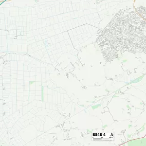
Bristol BS9 3 Map

![]()
Wall Art and Photo Gifts from Map Marketing
Bristol BS9 3 Map
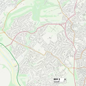
Postcode Sector Map of Bristol BS9 3
Media ID 19966373
Abbey Road Barley Croft Beverley Gardens Briarwood Bristol Church Road Churchill Drive College Road Coniston Avenue Cooper Road Cote Lane Downs Road Falcon Close High Street Hutton Close Lyndhurst Road Merlin Close Newcombe Road Oakhurst Road Orchard Close Red House Lane Shipley Road Southdown Road Southfield Road Stoke Lane The Dell Westfield Road Westover Road
FEATURES IN THESE COLLECTIONS
> Animals
> Birds
> Accipitriformes
> Falcons
> Merlin
> Europe
> United Kingdom
> England
> Bristol
> Bristol
> Europe
> United Kingdom
> England
> Bristol
> Henleaze
> Europe
> United Kingdom
> England
> Bristol
> Westbury Park
> Europe
> United Kingdom
> England
> Bristol
> Westbury on Trym
> Europe
> United Kingdom
> Wales
> Ceredigion
> Lampeter
> Map Marketing
> Postcode Sector Maps
> BS - Bristol
> Maps and Charts
> Related Images
MADE IN AUSTRALIA
Safe Shipping with 30 Day Money Back Guarantee
FREE PERSONALISATION*
We are proud to offer a range of customisation features including Personalised Captions, Color Filters and Picture Zoom Tools
SECURE PAYMENTS
We happily accept a wide range of payment options so you can pay for the things you need in the way that is most convenient for you
* Options may vary by product and licensing agreement. Zoomed Pictures can be adjusted in the Cart.