Home > Europe > United Kingdom > Wales > Maps
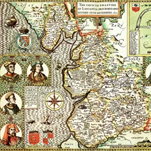
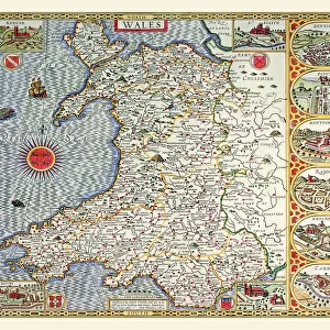
Old County Map of Denbighshire 1611 by John Speed

![]()
Wall Art and Photo Gifts from MapSeeker
Old County Map of Denbighshire 1611 by John Speed
A facimile of John Speeds historical map of Denbighshire originally published for the " Theatre of the Empire of Great Britain", an atlas to accompany " a history of Great Britain"
Welcome to the Mapseeker Image library and enter an historic gateway to one of the largest on-line collections of Historic Maps, Nostalgic Views, Vista's and Panorama's from a World gone by.
Media ID 20347701
© Mapseeker Publishing Ltd
County Map County Map Of Wales Historic Map John Speed Map Old County Map Old Welsh County Map Speed Map Speede Map Welsh County Map Denbighshire
FEATURES IN THESE COLLECTIONS
> Arts
> Artists
> S
> John Speed
> Europe
> United Kingdom
> Wales
> Denbighshire
> Related Images
> Europe
> United Kingdom
> Wales
> Maps
> Europe
> United Kingdom
> Wales
> Posters
> Europe
> United Kingdom
> Wales
> Related Images
> Maps and Charts
> British Empire Maps
> Maps and Charts
> Early Maps
> Maps and Charts
> Wales
> MapSeeker
> Maps from the British Isles
> England and Counties PORTFOLIO
> MapSeeker
> Maps from the British Isles
> Wales and Counties PORTFOLIO
EDITORS COMMENTS
This stunning print showcases the "Old County Map of Denbighshire 1611" by the renowned cartographer John Speed. Originally published for his monumental work, "The Theatre of the Empire of Great Britain" this facsimile captures the historical essence and intricate details of Speed's original map. Transporting us back in time to 17th-century Wales, this old Welsh county map offers a fascinating glimpse into Denbighshire's past. As part of an atlas designed to accompany "A History of Great Britain" it serves as both a geographical reference and a visual representation of the region's rich history. With its delicate lines and meticulous craftsmanship, this vintage county map provides an invaluable resource for historians, researchers, or anyone with an interest in Welsh heritage. The accuracy and attention to detail displayed by John Speed are evident in every corner, making it not just a functional tool but also a work of art. Denbighshire itself is beautifully depicted on this historic map, showcasing its towns, villages, rivers, and landmarks from centuries ago. Whether you're tracing your family roots or exploring the evolution of Welsh geography over time, this print allows you to immerse yourself in Denbighshire's past like never before. As we gaze upon this remarkable piece created by one of history's most celebrated cartographers – John Speed – we can't help but appreciate how maps have always been windows into our collective story.
MADE IN AUSTRALIA
Safe Shipping with 30 Day Money Back Guarantee
FREE PERSONALISATION*
We are proud to offer a range of customisation features including Personalised Captions, Color Filters and Picture Zoom Tools
SECURE PAYMENTS
We happily accept a wide range of payment options so you can pay for the things you need in the way that is most convenient for you
* Options may vary by product and licensing agreement. Zoomed Pictures can be adjusted in the Cart.