Home > Europe > France > Canton > Landes
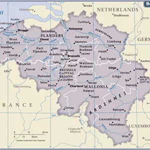
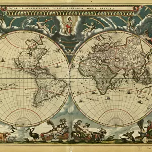
1710 De La Feuille Map Of The Netherlands Belgium And Luxembourg

![]()
Wall Art and Photo Gifts from Universal Images Group (UIG)
1710 De La Feuille Map Of The Netherlands Belgium And Luxembourg
1710, De La Feuille Map of the Netherlands, Belgium and Luxembourg
Universal Images Group (UIG) manages distribution for many leading specialist agencies worldwide
Media ID 38547855
© Artokoloro Quint Lox Limited
1710 Antique Map Latitude Longitude Mappa Mundi Old Antique Plan Old Antique View Ols Antique Map Rare Old Maps Topo
FEATURES IN THESE COLLECTIONS
> Europe
> Belgium
> Related Images
> Europe
> France
> Canton
> Landes
> Europe
> Luxembourg
> Maps
> Europe
> Luxembourg
> Related Images
> Europe
> Netherlands
> Maps
> Europe
> Netherlands
> Related Images
> Historic
> Space exploration
> Maps and Charts
> Early Maps
> Universal Images Group (UIG)
> History
> Historical Maps
EDITORS COMMENTS
Step back in time and explore the 1710 De La Feuille Map of the Netherlands, Belgium, and Luxembourg. This exquisite print is a stunning representation of the region's topography during the early 18th century. The intricate details on this vintage map showcase the geographical boundaries, cities, rivers, and mountains that define this beautiful corner of Europe.
The cartographer's skillful hand has carefully rendered every aspect of this region with precision and accuracy. From the winding rivers to the rolling hills, each feature is meticulously illustrated to provide a comprehensive understanding of the landscape. The use of color adds depth and dimensionality to the map, making it a true work of art.
This historic map is not only a fascinating piece for geography enthusiasts but also a valuable resource for anyone interested in history or travel. Imagine being able to navigate through these regions as they were over three centuries ago! Whether you're an historian, an artist, or simply someone who appreciates rare maps, this print is sure to captivate your imagination.
Take a journey through time with this incredible piece from Universal Images Group (UIG). Let its beauty inspire your sense of adventure and curiosity about our world's rich history.
MADE IN AUSTRALIA
Safe Shipping with 30 Day Money Back Guarantee
FREE PERSONALISATION*
We are proud to offer a range of customisation features including Personalised Captions, Color Filters and Picture Zoom Tools
SECURE PAYMENTS
We happily accept a wide range of payment options so you can pay for the things you need in the way that is most convenient for you
* Options may vary by product and licensing agreement. Zoomed Pictures can be adjusted in the Cart.