Home > Europe > France > Canton > Landes
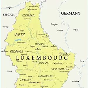
1730 Homann Heirs Map Of Belgium And Luxembourg

![]()
Wall Art and Photo Gifts from Universal Images Group (UIG)
1730 Homann Heirs Map Of Belgium And Luxembourg
1730, Homann Heirs Map of Belgium and Luxembourg
Universal Images Group (UIG) manages distribution for many leading specialist agencies worldwide
Media ID 38550182
© Artokoloro Quint Lox Limited
1730 Antique Map Latitude Longitude Mappa Mundi Old Antique Plan Old Antique View Ols Antique Map Rare Old Maps Topo
FEATURES IN THESE COLLECTIONS
> Europe
> Belgium
> Related Images
> Europe
> France
> Canton
> Landes
> Europe
> Luxembourg
> Maps
> Europe
> Luxembourg
> Related Images
> Historic
> Space exploration
> Maps and Charts
> Early Maps
> Maps and Charts
> Luxembourg
> Maps and Charts
> Related Images
> Universal Images Group (UIG)
> History
> Historical Maps
EDITORS COMMENTS
Step back in time to the 18th century with this stunning print of the Homann Heirs Map of Belgium and Luxembourg, circa 1730. This beautifully illustrated map is a testament to the artistry and cartographic skills of its creators, showcasing the region's topography with intricate detail.
The map features a charming mix of hand-drawn illustrations and precise geographical markings, highlighting major cities, rivers, and mountain ranges. The delicate borders and ornate typography add an air of elegance to this vintage treasure.
This historic map not only provides a fascinating glimpse into the past but also serves as a valuable resource for historians, geographers, and anyone interested in exploring the evolution of cartography. The Homann Heirs Map is an exquisite piece that would make a unique addition to any collection or decorative space.
Printed on high-quality paper, this reproduction maintains its original charm while ensuring durability for generations to come. Whether you're a history buff or simply appreciate beautiful artwork, this map is sure to delight.
MADE IN AUSTRALIA
Safe Shipping with 30 Day Money Back Guarantee
FREE PERSONALISATION*
We are proud to offer a range of customisation features including Personalised Captions, Color Filters and Picture Zoom Tools
SECURE PAYMENTS
We happily accept a wide range of payment options so you can pay for the things you need in the way that is most convenient for you
* Options may vary by product and licensing agreement. Zoomed Pictures can be adjusted in the Cart.