Home > Animals > Mammals > Cercopithecidae > Mauritius
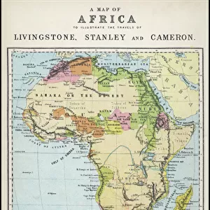
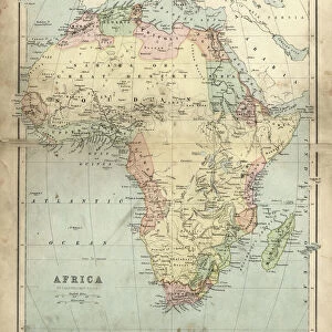
1770 Bonne Map Of East Africa Madagascar Isle Bourbon And Mauritius

![]()
Wall Art and Photo Gifts from Universal Images Group (UIG)
1770 Bonne Map Of East Africa Madagascar Isle Bourbon And Mauritius
1770, Bonne Map of East Africa, Madagascar, Isle Bourbon and Mauritius, Mozambique, Rigobert Bonne 1727 - 1794, one of the most important cartographers of the late 18th century
Universal Images Group (UIG) manages distribution for many leading specialist agencies worldwide
Media ID 38548065
© Artokoloro Quint Lox Limited
1770 Madagascar Rigobert Bonne 1727 – 1794 Antique Map Latitude Longitude Mappa Mundi Mozambique Old Antique Plan Old Antique View Ols Antique Map Rare Old Maps Topo
FEATURES IN THESE COLLECTIONS
> Africa
> Madagascar
> Maps
> Africa
> Madagascar
> Related Images
> Africa
> Mauritius
> Related Images
> Africa
> Mozambique
> Maps
> Africa
> Mozambique
> Related Images
> Africa
> Related Images
> Animals
> Mammals
> Cercopithecidae
> Mauritius
> Europe
> France
> Canton
> Landes
> Historic
> Space exploration
> Universal Images Group (UIG)
> History
> Historical Maps
EDITORS COMMENTS
Step back in time to the 18th century with this stunning print of Rigobert Bonne's 1770 map of East Africa, Madagascar, Isle Bourbon, and Mauritius. This exquisite illustration is a testament to the cartographer's skill and attention to detail, showcasing the region's topography with precision and beauty.
Bonne was one of the most important cartographers of his time, known for his meticulous work on maps that accurately depicted geographical features and navigational routes. This particular map is a remarkable example of his expertise, featuring intricate details such as latitude and longitude grids, mountain ranges, rivers, and coastal lines.
The map also highlights the strategic importance of these islands during a period of European exploration and colonization. Madagascar was a key stopover for ships traveling between Europe and Asia, while Isle Bourbon (now Réunion) was a French colony established in 1642. Mauritius was discovered by Portuguese explorers in 1598 but later became a British colony.
This vintage print is not only an impressive piece of historical geography but also an attractive addition to any room or study. Its aged appearance adds character to any space, making it perfect for those who appreciate antique maps or are fascinated by history.
MADE IN AUSTRALIA
Safe Shipping with 30 Day Money Back Guarantee
FREE PERSONALISATION*
We are proud to offer a range of customisation features including Personalised Captions, Color Filters and Picture Zoom Tools
SECURE PAYMENTS
We happily accept a wide range of payment options so you can pay for the things you need in the way that is most convenient for you
* Options may vary by product and licensing agreement. Zoomed Pictures can be adjusted in the Cart.