Home > Europe > France > Canton > Landes
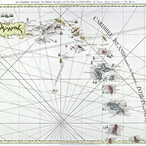
1780 Raynal And Bonne Map Of The Virgin Islands And Antilles

![]()
Wall Art and Photo Gifts from Universal Images Group (UIG)
1780 Raynal And Bonne Map Of The Virgin Islands And Antilles
1780, Raynal and Bonne Map of the Virgin Islands and Antilles, West Indies, Rigobert Bonne 1727 - 1794, one of the most important cartographers of the late 18th century
Universal Images Group (UIG) manages distribution for many leading specialist agencies worldwide
Media ID 38548213
© Artokoloro Quint Lox Limited
1780 Rigobert Bonne 1727 – 1794 West Indies Antique Map Latitude Longitude Mappa Mundi Old Antique Plan Old Antique View Ols Antique Map Rare Old Maps Topo
FEATURES IN THESE COLLECTIONS
> Europe
> France
> Canton
> Landes
> Historic
> Space exploration
> Maps and Charts
> Early Maps
> Maps and Charts
> Related Images
> Maps and Charts
> World
> North America
> US Virgin Islands
> Maps
> Universal Images Group (UIG)
> History
> Historical Maps
EDITORS COMMENTS
Step back in time to the late 18th century with this stunning print of Raynal and Bonne's map of the Virgin Islands and Antilles. Created by renowned cartographer Rigobert Bonne in 1780, this beautifully detailed illustration showcases the region's intricate geography, topography, and navigation routes.
As one of the most important cartographers of his era, Bonne was known for his meticulous attention to detail and commitment to accuracy. This map is a testament to his skill, featuring precise renderings of islands, bays, rivers, and mountains. The intricate grid system allows for easy navigation through the complex network of waterways and landmasses.
This vintage map is not only a fascinating piece of historical documentation but also a work of art that evokes a sense of adventure and exploration. Imagine setting sail across these waters or trekking through these uncharted territories as you gaze upon this beautiful print.
A true treasure for anyone interested in history, geography, or simply appreciating the beauty of antique maps.
MADE IN AUSTRALIA
Safe Shipping with 30 Day Money Back Guarantee
FREE PERSONALISATION*
We are proud to offer a range of customisation features including Personalised Captions, Color Filters and Picture Zoom Tools
SECURE PAYMENTS
We happily accept a wide range of payment options so you can pay for the things you need in the way that is most convenient for you
* Options may vary by product and licensing agreement. Zoomed Pictures can be adjusted in the Cart.