Home > Europe > France > Canton > Landes
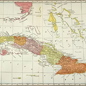
1864 Johnson's Map Of Cuba Jamaica The Bahamas And Puerto Rico

![]()
Wall Art and Photo Gifts from Universal Images Group (UIG)
1864 Johnson's Map Of Cuba Jamaica The Bahamas And Puerto Rico
1864, Johnson's Map of Cuba, Jamaica, the Bahamas and Puerto Rico
Universal Images Group (UIG) manages distribution for many leading specialist agencies worldwide
Media ID 38549392
© Artokoloro Quint Lox Limited
1864 Jamaica Antique Map Latitude Longitude Mappa Mundi Old Antique Plan Old Antique View Ols Antique Map Rare Old Maps Topo
FEATURES IN THESE COLLECTIONS
> Europe
> France
> Canton
> Landes
> Historic
> Space exploration
> Maps and Charts
> Early Maps
> Maps and Charts
> Related Images
> Maps and Charts
> World
> North America
> The Bahamas
> Maps
> North America
> The Bahamas
> Related Images
> North America
> Cuba
> Maps
> North America
> Cuba
> Related Images
> North America
> Jamaica
> Maps
> Universal Images Group (UIG)
> History
> Historical Maps
EDITORS COMMENTS
Step back in time to the mid-19th century with this stunning print of Johnson's Map of Cuba, Jamaica, the Bahamas and Puerto Rico (1864). This beautifully rendered map is a testament to the cartographic skills of its creator, showcasing the geographical details of these Caribbean islands with remarkable accuracy. The intricate topography is depicted in exquisite detail, featuring mountains, rivers, and coastlines that are still recognizable today.
The map also includes a wealth of information about each island's geography, including latitude and longitude coordinates. The illustration style is characteristic of 19th-century maps, with ornate borders and decorative flourishes adding an air of elegance to the design.
This vintage map would make a fascinating addition to any collection or study on geography, history or travel. It's a unique piece that not only provides insight into the region's physical landscape but also serves as a window into the past. Imagine being able to explore these islands as they were over 150 years ago - it's an opportunity that few get to experience firsthand.
Whether you're an armchair traveler or simply someone who appreciates beautiful art and design, this print is sure to captivate your imagination.
MADE IN AUSTRALIA
Safe Shipping with 30 Day Money Back Guarantee
FREE PERSONALISATION*
We are proud to offer a range of customisation features including Personalised Captions, Color Filters and Picture Zoom Tools
SECURE PAYMENTS
We happily accept a wide range of payment options so you can pay for the things you need in the way that is most convenient for you
* Options may vary by product and licensing agreement. Zoomed Pictures can be adjusted in the Cart.