Home > Europe > France > Canton > Landes
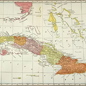
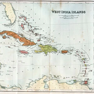
1872 Mitchell Map Of Cuba And The Bahamas Topography

![]()
Wall Art and Photo Gifts from Universal Images Group (UIG)
1872 Mitchell Map Of Cuba And The Bahamas Topography
1872, Mitchell Map of Cuba and the Bahamas
Universal Images Group (UIG) manages distribution for many leading specialist agencies worldwide
Media ID 38551955
© Artokoloro Quint Lox Limited
1872 Antique Map Latitude Longitude Mappa Mundi Old Antique Plan Old Antique View Ols Antique Map Rare Old Maps Topo
FEATURES IN THESE COLLECTIONS
> Europe
> France
> Canton
> Landes
> Historic
> Space exploration
> Maps and Charts
> Early Maps
> Maps and Charts
> Related Images
> Maps and Charts
> World
> North America
> The Bahamas
> Maps
> North America
> The Bahamas
> Related Images
> North America
> Cuba
> Maps
> North America
> Cuba
> Related Images
> Universal Images Group (UIG)
> History
> Historical Maps
EDITORS COMMENTS
Step back in time to the late 19th century with this stunning print of the 1872 Mitchell Map of Cuba and the Bahamas Topography. This exquisite illustration is a testament to the artistry and cartographic expertise of its creator, Samuel Augustus Mitchell Jr.
Published in Philadelphia by S.A. Mitchell & Co., this map showcases the geographical features of Cuba and the Bahamas with remarkable detail. The intricate design includes topographical information, including mountains, rivers, lakes, and coastal boundaries. The map also highlights major cities, towns, and ports, providing a glimpse into the region's urbanization during this period.
The vintage aesthetic of this print adds an air of nostalgia to any room or office space. Its unique blend of artistry and scientific precision makes it a fascinating piece for history buffs, geography enthusiasts, or anyone who appreciates rare maps.
This beautiful print is not only a decorative piece but also a window into the past. It provides insight into how our understanding of geography has evolved over time and serves as a reminder of humanity's enduring fascination with exploration and discovery.
MADE IN AUSTRALIA
Safe Shipping with 30 Day Money Back Guarantee
FREE PERSONALISATION*
We are proud to offer a range of customisation features including Personalised Captions, Color Filters and Picture Zoom Tools
SECURE PAYMENTS
We happily accept a wide range of payment options so you can pay for the things you need in the way that is most convenient for you
* Options may vary by product and licensing agreement. Zoomed Pictures can be adjusted in the Cart.