Jigsaw Puzzle > Europe > United Kingdom > England > London > Towns > Welling
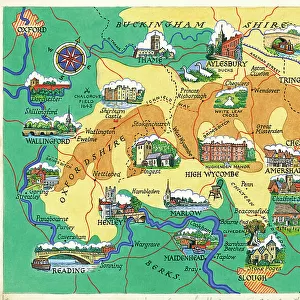
Jigsaw Puzzle : Old Map of the Environs of London 1836 by Thomas Moule


![]()
Jigsaw Puzzles from MapSeeker
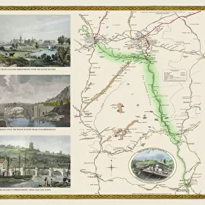
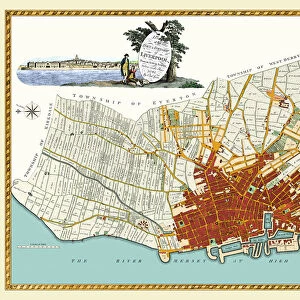
Old Map of the Environs of London 1836 by Thomas Moule
This is a fine decorative reproduction Map of The Environs of London from the First Edition series of Thomas Moule Maps, originally Published in 1836. The well-known series of County Maps which are known as Moules feature beautiful vignette views, there were also 4 " Environs" Maps included, and were first published in separate sections for each county in 1830-32, they were then published in collected form in a two-volume work: The English Counties Delineated: or a Topographical Description of England: Illustrated by a Complete Series of County Maps by Thomas Moule: London: Published by George Virtue 1836
Welcome to the Mapseeker Image library and enter an historic gateway to one of the largest on-line collections of Historic Maps, Nostalgic Views, Vista's and Panorama's from a World gone by.
Media ID 20348235
© Mapseeker Publishing Ltd
Historic Map London Map Map Of London Moule Map Old Moule Map Thomas Moule Thomas Moule Map Environs Of London
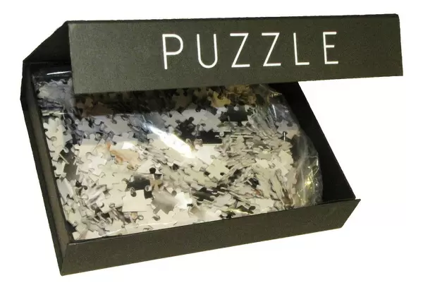
Jigsaw Puzzle (500 Pieces)
Discover the charm of the past with our Media Storehouse Old Map of the Environs of London 1836 by Thomas Moule jigsaw puzzle. This intricately detailed reproduction features the historical map by Thomas Moule and George Virtue, published by MapSeeker in the First Edition series. Travel back in time as you piece together this captivating puzzle, showcasing the sights and landmarks of London in 1836. Ideal for puzzle enthusiasts and history buffs alike, this high-quality jigsaw puzzle is a delightful way to unwind and explore the rich history of one of the world's most iconic cities.
500 piece puzzles are custom made in Australia and hand-finished on 100% recycled 1.6mm thick laminated puzzle boards. There is a level of repetition in jigsaw shapes with each matching piece away from its pair. The completed puzzle measures 40x51cm and is delivered packaged in an attractive presentation box specially designed to fit most mail slots with a unique magnetic lid
Jigsaw Puzzles are an ideal gift for any occasion
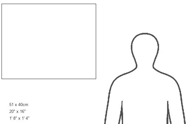
Estimated Product Size is 50.7cm x 40.3cm (20" x 15.9")
These are individually made so all sizes are approximate
Artwork printed orientated as per the preview above, with landscape (horizontal) or portrait (vertical) orientation to match the source image.
FEATURES IN THESE COLLECTIONS
> Arts
> Artists
> M
> Thomas Moule
> Europe
> United Kingdom
> England
> London
> Towns
> Welling
> Europe
> United Kingdom
> England
> Maps
> Europe
> United Kingdom
> England
> Wells
> MapSeeker
> British Town And City Plans
> English & Welsh PORTFOLIO
EDITORS COMMENTS
This stunning print showcases the "Old Map of the Environs of London 1836" by Thomas Moule, a renowned cartographer from the 19th century. Originally published in 1836 as part of Moule's series of County Maps, this particular map focuses on the surrounding areas of London. The intricate details and exquisite craftsmanship make this decorative reproduction a true work of art. The map features beautiful vignette views that add charm and character to its overall design. It is evident that Moule had a deep appreciation for both accuracy and aesthetics when creating his maps. Published by George Virtue in 1836, this map was part of a larger two-volume work titled "The English Counties Delineated: or a Topographical Description of England". This comprehensive collection included not only county maps but also four additional "Environs" maps like the one displayed here. As you explore this historic map, you can't help but be transported back in time to early 19th-century London. Every street, river, and landmark is meticulously depicted, offering a glimpse into what life was like during that era. Whether you are an avid history enthusiast or simply appreciate fine artistry, this print captures the essence and beauty of Thomas Moule's iconic cartography. Display it proudly in your home or office to admire its rich historical significance and timeless appeal.
MADE IN AUSTRALIA
Safe Shipping with 30 Day Money Back Guarantee
FREE PERSONALISATION*
We are proud to offer a range of customisation features including Personalised Captions, Color Filters and Picture Zoom Tools
SECURE PAYMENTS
We happily accept a wide range of payment options so you can pay for the things you need in the way that is most convenient for you
* Options may vary by product and licensing agreement. Zoomed Pictures can be adjusted in the Cart.