Canvas Print > Africa > Algeria > Maps
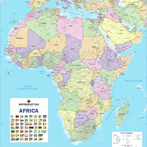
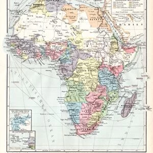
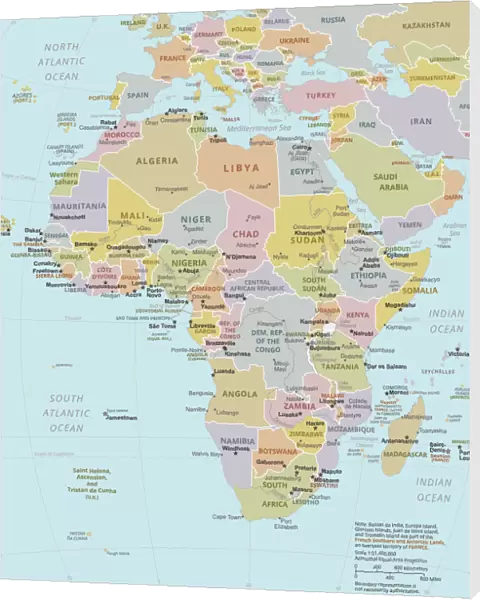
Canvas Print : Political Map of Africa


![]()
Canvas Prints from Fine Art Storehouse
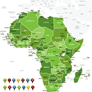
Political Map of Africa
Vector Illustration of the policital map of Africa
Reference map as created by the US Central Intelligence Agency
Unleash your creativity and transform your space into a visual masterpiece!
calvindexter
Media ID 20251035
Adventure Algeria Backgrounds Business Concepts Creativity Data Design Element Division Exploration Global Communications Government Icon Ideas Indian Ocean Infographic International Border Island Journey Kenya Land Libya Madagascar Newspaper Outline Politics Sign Silhouette South Africa Sudan Symbol Technology Topography Trip Unity Vector World Map Mauritania Nigeria Political Map Social Media South Atlantic Ocean
20"x16" (51x41cm) Canvas Print
Discover the captivating "Political Map of Africa" by calvindexter, now available as a stunning Canvas Print from Media Storehouse. This exquisite artwork is a vector illustration, meticulously crafted with intricate detail and precision. Inspired by the reference map created by the US Central Intelligence Agency, this Political Map of Africa Canvas Print is a must-have for history enthusiasts, geography aficionados, and anyone with a passion for world culture. Bring the rich diversity of Africa into your home or office with this beautifully rendered, high-quality Canvas Print that is sure to make a bold statement. Order yours today and join the countless others who have elevated their spaces with Media Storehouse's exceptional Canvas Prints.
Delivered stretched and ready to hang our premium quality canvas prints are made from a polyester/cotton blend canvas and stretched over a 1.25" (32mm) kiln dried knot free wood stretcher bar. Packaged in a plastic bag and secured to a cardboard insert for safe transit.
Canvas Prints add colour, depth and texture to any space. Professionally Stretched Canvas over a hidden Wooden Box Frame and Ready to Hang
Estimated Product Size is 40.6cm x 50.8cm (16" x 20")
These are individually made so all sizes are approximate
Artwork printed orientated as per the preview above, with portrait (vertical) orientation to match the source image.
FEATURES IN THESE COLLECTIONS
> Africa
> Algeria
> Related Images
> Africa
> Kenya
> Related Images
> Africa
> Libya
> Related Images
> Africa
> Madagascar
> Maps
> Africa
> Madagascar
> Related Images
> Africa
> Mauritania
> Maps
> Africa
> Mauritania
> Related Images
> Maps and Charts
> Popular Maps
> Fine Art Storehouse
> Map
> Reference Maps
> Fine Art Storehouse
> Top Sellers - Art Prints
EDITORS COMMENTS
This print showcases the intricate and detailed "Political Map of Africa". Created by the US Central Intelligence Agency, this vector illustration is a true masterpiece of cartography. The map encompasses the vast African continent, highlighting its diverse countries and their political boundaries. With its vibrant colors and precise design elements, this artwork sparks creativity and ignites a sense of exploration. It invites viewers on a journey to discover Africa's rich cultural heritage, breathtaking coastlines, and enchanting islands. Whether you are an adventurer or simply fascinated by world maps, this print will transport you to new horizons. Beyond its aesthetic appeal, this map symbolizes more than just geography; it represents government systems, politics, unity, division, global communications, and international borders. It serves as a powerful reminder of our interconnectedness in today's fast-paced world. Perfect for any business or technology setting seeking inspiration or adding visual interest to their space - be it an office backdrop or social media content - this print seamlessly combines artistry with informative data. Its topographical features beautifully depict Africa's physical geography while conveying essential information about each country. From Algeria to South Africa and from Libya to Madagascar – every nation is meticulously outlined within the silhouette of the continent itself. This stunning piece captures both the beauty and complexity that define Africa while offering endless possibilities for interpretation and appreciation.
MADE IN AUSTRALIA
Safe Shipping with 30 Day Money Back Guarantee
FREE PERSONALISATION*
We are proud to offer a range of customisation features including Personalised Captions, Color Filters and Picture Zoom Tools
SECURE PAYMENTS
We happily accept a wide range of payment options so you can pay for the things you need in the way that is most convenient for you
* Options may vary by product and licensing agreement. Zoomed Pictures can be adjusted in the Cart.