Cushion > Historic > Ancient civilizations > Ancient Greece > Greek mythology
Cushion : Platos map of Atlantis, artwork


![]()
Home Decor From Science Photo Library
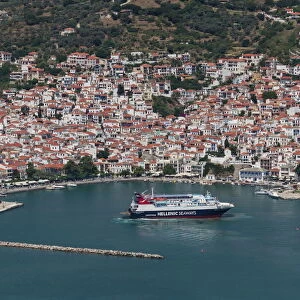
Platos map of Atlantis, artwork
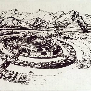
Platos map of Atlantis, artwork. Artwork of the mythological city of Atlantis, as described by the Ancient Greek philosopher Plato. Plato made the first written references to Atlantis in 360 BC. He suggested that Atlantis was located on an island at the mouth of the Pillars of Hercules in what is now called the Strait of Gibraltar. Despite many expeditions, the existence and location of Atlantis has not yet been confirmed. Legend has it that Atlantis was destroyed by a great flood and was submerged beneath the sea around 9600 BC
Science Photo Library features Science and Medical images including photos and illustrations
Media ID 9218665
© MIKKEL JUUL JENSEN / SCIENCE PHOTO LIBRARY
Aerial View Ancient Archaeological Archaeology Archeological Archeology Atlantis Building Buildings Canals City Civilisation Classical From Above Island Legend Legendary Lost City Myth Mythical Mythological Mythology Plato Urban Waterway Platos
Cushion
Refresh your home decor with a beautiful full photo 16"x16" (40x40cm) cushion, complete with cushion pad insert. Printed on both sides and made from 100% polyester with a zipper on the bottom back edge of the cushion cover. Care Instructions: Warm machine wash, do not bleach, do not tumble dry. Warm iron inside out. Do not dry clean.
Accessorise your space with decorative, soft cushions
Estimated Product Size is 40cm x 40cm (15.7" x 15.7")
These are individually made so all sizes are approximate
Artwork printed orientated as per the preview above, with landscape (horizontal) or portrait (vertical) orientation to match the source image.
FEATURES IN THESE COLLECTIONS
> Aerial Photography
> Related Images
> Europe
> Greece
> Aerial Views
> Europe
> Greece
> Related Images
> Historic
> Ancient civilizations
> Ancient Greece
> Greek history
> Historic
> Ancient civilizations
> Ancient Greece
> Greek mythology
> Maps and Charts
> Early Maps
> Popular Themes
> Plato
EDITORS COMMENTS
This artwork, titled "Plato's Map of Atlantis" takes us on a journey into the realm of myth and imagination. Inspired by the ancient Greek philosopher Plato's descriptions, this illustration depicts the legendary city of Atlantis. According to Plato's writings in 360 BC, Atlantis was believed to be situated on an island at the entrance of the Pillars of Hercules, now known as the Strait of Gibraltar. The artist skillfully brings to life this mythical civilization that has fascinated scholars and adventurers for centuries. With its classical architecture and intricate waterways, the image offers a bird's-eye view of a lost city shrouded in mystery. However, despite numerous expeditions and extensive research conducted by archaeologists and historians alike, no concrete evidence confirming Atlantis' existence or precise location has been found. The legend suggests that around 9600 BC, Atlantis met its tragic fate when it was submerged beneath the sea due to a cataclysmic flood. As we gaze upon this mesmerizing print from Science Photo Library, we are reminded not only of our fascination with ancient civilizations but also how tales passed down through generations can capture our collective imagination. Whether real or imagined, Atlantis continues to captivate our minds as one of history's greatest enigmas—a testament to humanity's enduring curiosity about our past.
MADE IN AUSTRALIA
Safe Shipping with 30 Day Money Back Guarantee
FREE PERSONALISATION*
We are proud to offer a range of customisation features including Personalised Captions, Color Filters and Picture Zoom Tools
SECURE PAYMENTS
We happily accept a wide range of payment options so you can pay for the things you need in the way that is most convenient for you
* Options may vary by product and licensing agreement. Zoomed Pictures can be adjusted in the Basket.