Fine Art Print > Africa > Egypt > Maps
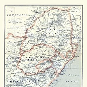
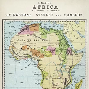
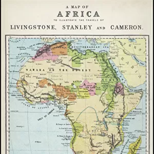
Fine Art Print : Map of Africa 1895

![]()
Fine Art Prints From Fine Art Storehouse
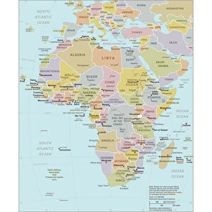
Map of Africa 1895
The Rand-McNally Grammar School Geography 1895 - Chicago & New York
Unleash your creativity and transform your space into a visual masterpiece!
THEPALMER
Media ID 14824631
© This content is subject to copyright
Central Africa East Africa Egypt Madagascar Sahara Somalia South Africa Sudan
20"x16" (+3" Border) Fine Art Print
Discover the captivating history of cartography with our exquisite Map of Africa 1895 by THEPALMER from the Media Storehouse Fine Art Prints collection. This vintage geography masterpiece, originally published by Rand-McNally for Grammar School use in Chicago and New York, showcases intricate details of the African continent as it was known over a century ago. Bring a piece of historical cartography into your home or office and transport yourself back in time with this beautifully detailed and intriguing fine art print.
20x16 image printed on 26x22 Fine Art Rag Paper with 3" (76mm) white border. Our Fine Art Prints are printed on 300gsm 100% acid free, PH neutral paper with archival properties. This printing method is used by museums and art collections to exhibit photographs and art reproductions.
Our fine art prints are high-quality prints made using a paper called Photo Rag. This 100% cotton rag fibre paper is known for its exceptional image sharpness, rich colors, and high level of detail, making it a popular choice for professional photographers and artists. Photo rag paper is our clear recommendation for a fine art paper print. If you can afford to spend more on a higher quality paper, then Photo Rag is our clear recommendation for a fine art paper print.
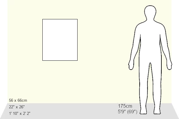
Estimated Image Size (if not cropped) is 40.6cm x 50.8cm (16" x 20")
Estimated Product Size is 55.9cm x 66cm (22" x 26")
These are individually made so all sizes are approximate
Artwork printed orientated as per the preview above, with portrait (vertical) orientation to match the source image.
FEATURES IN THESE COLLECTIONS
> Africa
> Egypt
> Related Images
> Africa
> Madagascar
> Maps
> Africa
> Madagascar
> Related Images
> Africa
> Somalia
> Related Images
> Africa
> South Africa
> Maps
> Africa
> South Africa
> Related Images
> Africa
> South Sudan
> Maps
> Africa
> South Sudan
> Related Images
> Fine Art Storehouse
> Map
> Historical Maps
EDITORS COMMENTS
This photo print, titled "Map of Africa 1895" takes us on a journey back in time to the late 19th century. The map, sourced from the renowned Rand-McNally Grammar School Geography book published in Chicago and New York, offers a glimpse into the intricate details and vastness of the African continent as it was known over a century ago. The map showcases various regions including Central Africa, East Africa, Egypt, Madagascar, Sahara Desert, Somalia, South Africa, Sudan and more. With its rich colors and meticulous cartographic workmanship by THEPALMER artist from Fine Art Storehouse collection; this piece is not only visually stunning but also historically significant. As we gaze upon this vintage treasure hanging on our walls or displayed in an art gallery setting; we are transported to an era when exploration was at its peak. It reminds us of the intrepid adventurers who embarked on daring expeditions across uncharted territories within Africa's diverse landscapes. Beyond its aesthetic appeal lies a deeper appreciation for the cultural heritage and geographical knowledge that has shaped our understanding of this magnificent continent. This artwork serves as a testament to human curiosity and discovery while honoring the craftsmanship involved in creating such detailed maps during an era without modern technology. "Map of Africa 1895" invites us to reflect on how far we have come since then while igniting our wanderlust for exploring new horizons both geographically and intellectually.
MADE IN AUSTRALIA
Safe Shipping with 30 Day Money Back Guarantee
FREE PERSONALISATION*
We are proud to offer a range of customisation features including Personalised Captions, Color Filters and Picture Zoom Tools
SECURE PAYMENTS
We happily accept a wide range of payment options so you can pay for the things you need in the way that is most convenient for you
* Options may vary by product and licensing agreement. Zoomed Pictures can be adjusted in the Basket.