Framed Print > Arts > Landscape paintings > Forest and woodland scenes > Forest artwork
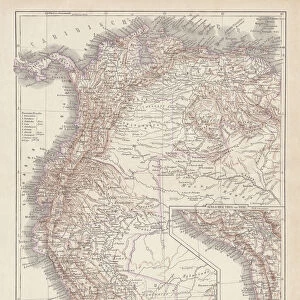
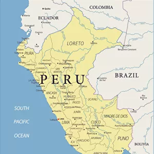
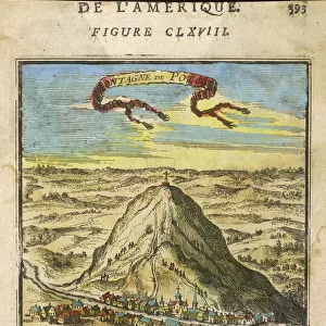
Framed Print : Map of Peru 1683 Mallet


![]()
Framed Photos from Mary Evans Picture Library
Map of Peru 1683 Mallet
Perou. A map showing a coastal part of South America on the South Pacific. Both the equator and tropic of Capricorn are given
Mary Evans Picture Library makes available wonderful images created for people to enjoy over the centuries
Media ID 589249
© Mary Evans Picture Library 2015 - https://copyrighthub.org/s0/hub1/creation/maryevans/MaryEvansPictureID/10173759
1683 Amazon Capricorn Equator Forest Mallet Maps Pacific Peru Rain Tropic Perou
A2 Premium Frame with A3 Poster
Discover the rich history and geography of South America with our exquisite Framed Prints from the Media Storehouse collection, featuring the captivating "Map of Peru 1683 Mallet" by Mary Evans Picture Library. This vintage map print transports you back in time, showcasing a coastal part of South America on the South Pacific. The intricate details reveal the explorations of the 17th century, with the equator and the tropic of Capricorn clearly marked. Elevate your home or office decor with this stunning, historically significant piece.
Premium Paradise Wooden Range A2 Premium Poster Frame (62x45cm) with A3 Poster (42x30cm) and mounted behind a white matt board to make your photo really stand out. FSC Certified and Rainforest Alliance Certified for environmental, social, and economic sustainably. High transparency tempered glass window with a smooth finished frame. Great for filling empty walls, decorating blank spaces, or creating eye-catching gallery walls. Frames arrive ready to hang. Sent with secure, protective packaging. Smooth wooden veneer mimics the real wood look and feel with ultra-durable scratch resistance tempered glass.
Contemporary Framed and Mounted Prints - Professionally Made and Ready to Hang
Estimated Image Size (if not cropped) is 40.4cm x 40.4cm (15.9" x 15.9")
Estimated Product Size is 44.6cm x 62cm (17.6" x 24.4")
These are individually made so all sizes are approximate
Artwork printed orientated as per the preview above, with landscape (horizontal) or portrait (vertical) orientation to match the source image.
FEATURES IN THESE COLLECTIONS
> Arts
> Artists
> O
> Oceanic Oceanic
> Arts
> Landscape paintings
> Forest and woodland scenes
> Forest artwork
> Maps and Charts
> Early Maps
> Maps and Charts
> Related Images
> South America
> Peru
> Maps
> South America
> Peru
> Related Images
> South America
> Related Images
EDITORS COMMENTS
This historical map, titled "Perou" and dated 1683, is an intriguing glimpse into the cartographic knowledge of the coastal region of South America during the late 17th century. Produced by the renowned French cartographer Guillaume Sanson and published by Jean Baptiste Nolin, this map is an important representation of the geographical understanding of the area during this time. The map focuses on the coastal part of modern-day Peru, stretching from the northern tip of Ecuador to the southernmost point of Chile. The mapmaker meticulously delineates the rugged coastline, marking various bays, inlets, and capes with great detail. The vast expanse of the Pacific Ocean is depicted to the west, with the equator and the tropic of Capricorn clearly indicated. The Amazon River, the lifeblood of the region, is shown flowing into the Atlantic Ocean, adding to the map's richness and depth. The dense forested areas, teeming with diverse flora and fauna, are depicted with a sense of wonder and curiosity, reflecting the exploratory spirit of the time. The map also includes various place names, some of which are still in use today, such as the cities of Lima, Callao, and Arica. The cartouche at the bottom right corner features an elegant design, complete with a view of a coastal scene, a native American figure, and a European explorer, highlighting the interconnectedness of the Old and New Worlds during this period. This map, created by Guillaume Sanson and published by Jean Baptiste Nolin in 1683, is a valuable historical document that offers a fascinating glimpse into the cartographic knowledge and understanding of the coastal region of South America during the late 17th century. It is a testament to the rich history and diverse geography of the area, and a reminder of the exploratory spirit that drove the cartographic endeavors of the time.
MADE IN AUSTRALIA
Safe Shipping with 30 Day Money Back Guarantee
FREE PERSONALISATION*
We are proud to offer a range of customisation features including Personalised Captions, Color Filters and Picture Zoom Tools
SECURE PAYMENTS
We happily accept a wide range of payment options so you can pay for the things you need in the way that is most convenient for you
* Options may vary by product and licensing agreement. Zoomed Pictures can be adjusted in the Cart.