Greetings Card > Aerial Photography > Austria
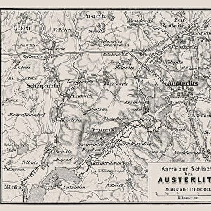
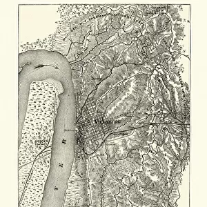
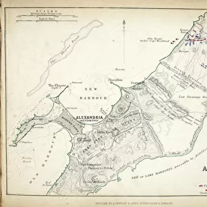
Greetings Card : Map of the Battle of Austerlitz, published by William Blackwood and Sons


![]()
Cards From Fine Art Finder
Map of the Battle of Austerlitz, published by William Blackwood and Sons
746911 Map of the Battle of Austerlitz, published by William Blackwood and Sons, Edinburgh & London, 1848 (hand-coloured engraving) by Johnston, Alexander Keith (1804-71); Private Collection; (add.info.: Battle of Austerlitz (2 December 1805)); The Stapleton Collection; Scottish, out of copyright
Media ID 23168512
© The Stapleton Collection / Bridgeman Images
Aerial View Armies Mapping Napoleon Positions
Greetings Card (7"x5")
Step back in time with our exquisite Map of the Battle of Austerlitz greeting cards from Media Storehouse. This captivating design, published by William Blackwood and Sons in 1848, showcases an intricately detailed hand-coloured engraving by Johnston. Perfect for history enthusiasts or those with a passion for military strategy, this stunning map offers a unique and thoughtful way to express your sentiments. Let the rich history of the Battle of Austerlitz be the backdrop for your message, adding depth and character to your greeting. Order now and let the recipient be transported to the heart of this iconic battle.
Folded Greeting Cards (12.5x17.5 cm) have a laminate finish and are supplied with an envelope. The front and inside can be personalised with text in a selection of fonts, layouts and colours.
Greetings Cards suitable for Birthdays, Weddings, Anniversaries, Graduations, Thank You and much more
Estimated Product Size is 12.5cm x 17.5cm (4.9" x 6.9")
These are individually made so all sizes are approximate
Artwork printed orientated as per the preview above, with landscape (horizontal) or portrait (vertical) orientation to match the source image.
FEATURES IN THESE COLLECTIONS
> Fine Art Finder
> Artists
> Alexander Keith Johnston
> Fine Art Finder
> Maps (celestial & Terrestrial)
> Aerial Photography
> Austria
> Aerial Photography
> Related Images
> Aerial Photography
> Scotland
> Arts
> Artists
> A
> William Alexander
> Arts
> Artists
> K
> William Keith
> Europe
> Austria
> Aerial Views
EDITORS COMMENTS
This print showcases a remarkable piece of history, the "Map of the Battle of Austerlitz". Published in 1848 by William Blackwood and Sons, this hand-coloured engraving by Alexander Keith Johnston provides an aerial view of one of Napoleon's most significant victories. The Battle of Austerlitz took place on 2 December 1805 and is also known as the Battle of the Three Emperors. The intricately detailed map allows us to delve into the strategic positions and movements of both French and Austrian armies during this historic clash. It offers a glimpse into the c19th era when cartography was essential for military planning. The presence of Russian forces is also depicted, highlighting their involvement in this monumental battle. As we observe this meticulously crafted engraving from Bridgeman Images' Private Collection, we are transported back in time to witness Napoleon's tactical brilliance unfold before our eyes. The vibrant hand-colouring adds depth and life to every line drawn on this historical document. This extraordinary print not only serves as a testament to Johnston's skillful artistry but also reminds us that even centuries later, battles like these continue to captivate our imagination. It stands as a tribute to those who fought bravely on both sides while offering invaluable insights into an important chapter in European history.
MADE IN AUSTRALIA
Safe Shipping with 30 Day Money Back Guarantee
FREE PERSONALISATION*
We are proud to offer a range of customisation features including Personalised Captions, Color Filters and Picture Zoom Tools
SECURE PAYMENTS
We happily accept a wide range of payment options so you can pay for the things you need in the way that is most convenient for you
* Options may vary by product and licensing agreement. Zoomed Pictures can be adjusted in the Basket.