Greetings Card > Aerial Photography > Austria
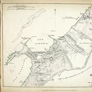
Greetings Card : Map of Prussia and Poland, published by William Blackwood and Sons, Edinburgh & London


![]()
Cards from Fine Art Finder
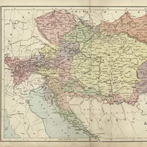
Map of Prussia and Poland, published by William Blackwood and Sons, Edinburgh & London
746910 Map of Prussia and Poland, published by William Blackwood and Sons, Edinburgh & London, 1848 (hand-coloured engraving) by Johnston, Alexander Keith (1804-71); Private Collection; The Stapleton Collection; Scottish, out of copyright
Media ID 22963674
© The Stapleton Collection / Bridgeman Images
1806 Aerial View Borders Campaigns Mapping Poland Polish Prussians Austria Austrian Prussia
Greetings Card (7"x5")
Step back in time with our exquisite Map of Prussia and Poland greeting card from the Media Storehouse collection, published by William Blackwood and Sons in 1848. This beautifully detailed, hand-coloured engraving by Johnston, now available as a greeting card, showcases the historical borders of Prussia and Poland. A perfect gift for history enthusiasts, geography buffs, or anyone who appreciates the beauty of vintage maps. Send a piece of the past with this unique and thoughtful card.
Folded Greeting Cards (12.5x17.5 cm) have a laminate finish and are supplied with an envelope. The front and inside can be personalised with text in a selection of fonts, layouts and colours.
Greetings Cards suitable for Birthdays, Weddings, Anniversaries, Graduations, Thank You and much more
Estimated Product Size is 12.5cm x 17.5cm (4.9" x 6.9")
These are individually made so all sizes are approximate
Artwork printed orientated as per the preview above, with landscape (horizontal) or portrait (vertical) orientation to match the source image.
FEATURES IN THESE COLLECTIONS
> Fine Art Finder
> Artists
> Alexander Keith Johnston
> Fine Art Finder
> Maps (celestial & Terrestrial)
> Aerial Photography
> Austria
> Aerial Photography
> Related Images
> Aerial Photography
> Scotland
> Arts
> Artists
> A
> William Alexander
> Arts
> Artists
> K
> William Keith
> Europe
> Austria
> Aerial Views
EDITORS COMMENTS
This print showcases a remarkable piece of history - the "Map of Prussia and Poland" published by William Blackwood and Sons in Edinburgh & London in 1848. The hand-coloured engraving, created by Alexander Keith Johnston, offers an aerial view of the region during the 19th century. The map depicts intricate borders that were constantly shifting due to political campaigns and power struggles. It provides a fascinating glimpse into the complex relationships between Prussia, Russia, Austria, and Poland during this era. The detailed mapping highlights key historical events such as the Austrian campaign in 1806. As you explore this artwork, you can't help but marvel at its precision and attention to detail. Each line represents not only physical boundaries but also echoes of past conflicts and alliances within Europe. This map serves as a testament to the importance of cartography in understanding our world's ever-changing geopolitical landscape. With its vibrant colors and expertly engraved features, this print from Bridgeman Images transports us back in time while reminding us of how interconnected European nations have been throughout history. It is a valuable addition to any collection or study on European history or cartography enthusiasts seeking insight into one of Europe's most intriguing regions – Prussia and Poland.
MADE IN AUSTRALIA
Safe Shipping with 30 Day Money Back Guarantee
FREE PERSONALISATION*
We are proud to offer a range of customisation features including Personalised Captions, Color Filters and Picture Zoom Tools
SECURE PAYMENTS
We happily accept a wide range of payment options so you can pay for the things you need in the way that is most convenient for you
* Options may vary by product and licensing agreement. Zoomed Pictures can be adjusted in the Cart.