Jigsaw Puzzle > Maps and Charts > Early Maps
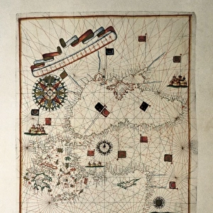
Jigsaw Puzzle : Description de la Terre Universelle (1667). Map
. Map")

. Map")

![]()
Jigsaw Puzzles from Mary Evans Picture Library
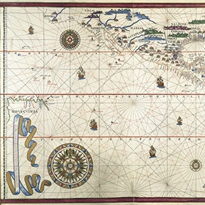
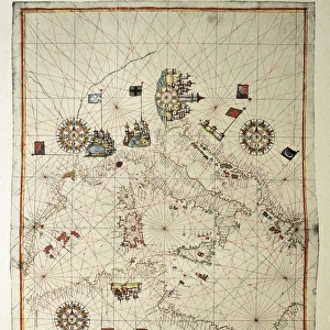
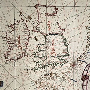
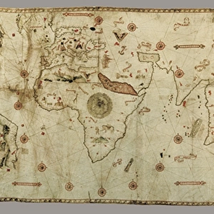
Description de la Terre Universelle (1667). Map
Description de la Terre Universelle (1667). Map. Engraving
Mary Evans Picture Library makes available wonderful images created for people to enjoy over the centuries
Media ID 8272173
© Mary Evans Picture Library 2015 - https://copyrighthub.org/s0/hub1/creation/maryevans/MaryEvansPictureID/10685826
Alpha Cartographic Cartographies Cartography Description Earth Engravings Equator Equatorial Maps Navigation Omega Sail Terre Terrestrial Universelle
Jigsaw Puzzle (500 Pieces)
Discover the beauty and intrigue of the past with Media Storehouse's collection of jigsaw puzzles featuring the "Description de la Terre Universelle (1667). Map" by Rights Managed from Mary Evans Prints Online. This captivating puzzle showcases an engraving of an ancient world map, a testament to the cartography of yesteryears. Immerse yourself in the historical detail and precision as you piece together this intricate jigsaw puzzle, transporting you back in time. Perfect for puzzle enthusiasts, history buffs, or anyone seeking a challenging and rewarding pastime. Bring the wisdom of the ages into your home with Media Storehouse's high-quality jigsaw puzzles.
500 piece puzzles are custom made in Australia and hand-finished on 100% recycled 1.6mm thick laminated puzzle boards. There is a level of repetition in jigsaw shapes with each matching piece away from its pair. The completed puzzle measures 40x51cm and is delivered packaged in an attractive presentation box specially designed to fit most mail slots with a unique magnetic lid
Jigsaw Puzzles are an ideal gift for any occasion
Estimated Product Size is 50.7cm x 40.3cm (20" x 15.9")
These are individually made so all sizes are approximate
Artwork printed orientated as per the preview above, with landscape (horizontal) or portrait (vertical) orientation to match the source image.
FEATURES IN THESE COLLECTIONS
> Maps and Charts
> Early Maps
> Maps and Charts
> Related Images
EDITORS COMMENTS
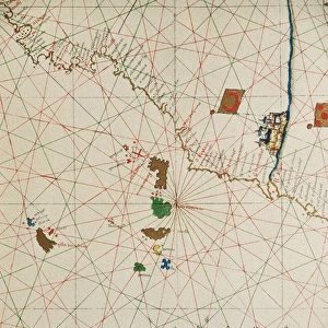
This stunning engraving is a captivating glimpse into the historical world of cartography during the 17th century. The "Description de la Terre Universelle" or "Description of the Universal Earth," created in 1667, is a remarkable example of early terrestrial mapping. The map's title, written in elegant script, is situated at the top, with the equator and meridian lines clearly marked, dividing the map into quadrants. The map's horizontal orientation, a departure from the traditional vertical format, reflects the growing influence of the nautical community in cartography. The map's intricate detailing showcases the known world as it was understood during that time, with accurate depictions of continents, islands, and major bodies of water. The map's color palette, while not vibrant by today's standards, would have been a significant improvement over the monochrome maps of the past. The map's border is adorned with various decorative elements, including intricate engravings of sailing ships and the Greek letters Alpha and Omega, symbolizing the beginning and end of the world. The map's creation was a testament to the advancements in navigation and cartography during the Age of Exploration. It served as a valuable tool for navigators and explorers, helping them to chart their courses and expand the boundaries of human knowledge. Today, this engraving stands as a reminder of the rich history of cartography and the enduring allure of the world's vast and mysterious landscapes.
MADE IN AUSTRALIA
Safe Shipping with 30 Day Money Back Guarantee
FREE PERSONALISATION*
We are proud to offer a range of customisation features including Personalised Captions, Color Filters and Picture Zoom Tools
SECURE PAYMENTS
We happily accept a wide range of payment options so you can pay for the things you need in the way that is most convenient for you
* Options may vary by product and licensing agreement. Zoomed Pictures can be adjusted in the Cart.