Metal Print > Maps and Charts > Early Maps
Metal Print : Map Geographical Advantages Constantinople Cartography


![]()
Metal Prints from Design Pics
Map Geographical Advantages Constantinople Cartography
Map to illustrate the geographical advantages of Constantinople. From the book Outline of History by H.G. Wells, published 1920
Design Pics offers Distinctively Different Imagery representing over 1,500 contributors
Media ID 32815201
© Ken Welsh
Cartography Chart Constantinople Countries Geographical Geography Advantages
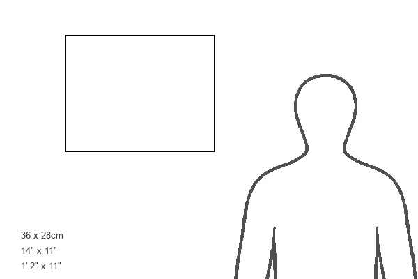
14"x11" (28x35cm) Metal Print
Discover the historical significance of Constantinople with our stunning Metal Prints from Media Storehouse. Featuring the captivating Map Geographical Advantages: Constantinople Cartography by Ken Welsh from Design Pics, this print showcases the strategic geographical advantages that made Constantinople a key city in history, as described in H.G. Wells' Outline of History. Each Metal Print is meticulously crafted with a vibrant, high-definition image transferred onto a sturdy aluminum sheet, resulting in a sleek, modern, and long-lasting display. Bring history to life in your home or office with this beautiful and educational addition.
Our Metal Prints feature rounded corners and rear fixings for easy wall mounting. Images are directly printed onto a lightweight, high quality 5mm thick, durable metallic surface for a vivid and vibrant finish. Available in 2 sizes, 28x35cm (14x11) and 50x40cm (20x16). The unique material is fade, moisture, chemical and scratch resistant to help ensure this art lasts a lifetime.
Made with durable metal and luxurious printing techniques, metal prints bring images to life and add a modern touch to any space
Estimated Product Size is 35.5cm x 27.9cm (14" x 11")
These are individually made so all sizes are approximate
Artwork printed orientated as per the preview above, with landscape (horizontal) or portrait (vertical) orientation to match the source image.
FEATURES IN THESE COLLECTIONS
> Maps and Charts
> Early Maps
> Maps and Charts
> Related Images
EDITORS COMMENTS
This print takes us back in time to the early 20th century, offering a glimpse into the historical significance of Constantinople. The image showcases an exquisite map, meticulously crafted through cartography, and sourced from H. G. Wells' renowned book "Outline of History" published in 1920. The map itself is a testament to the artistry and precision of engraving techniques during that period. It beautifully illustrates the geographical advantages bestowed upon Constantinople, which undoubtedly played a pivotal role in shaping its prominence throughout history. As we delve into this archival gem, we are transported to an era where maps were not just tools for navigation but also works of art. Every detail on this vintage illustration speaks volumes about the strategic importance of Constantinople as it highlights key countries and regions surrounding this magnificent city. With its prime location at the crossroads between Europe and Asia, Constantinople enjoyed unparalleled access to trade routes and served as a gateway between two continents. Its unique position along major waterways provided both economic prosperity and military advantage. Through Ken Welsh's lens, this picture offers us an opportunity to appreciate not only the historical context but also marvel at how cartography was once considered an intricate form of storytelling. This remarkable visual representation serves as a reminder that even amidst modern technological advancements, there is still immense beauty in preserving our past through such timeless artifacts.
MADE IN AUSTRALIA
Safe Shipping with 30 Day Money Back Guarantee
FREE PERSONALISATION*
We are proud to offer a range of customisation features including Personalised Captions, Color Filters and Picture Zoom Tools
SECURE PAYMENTS
We happily accept a wide range of payment options so you can pay for the things you need in the way that is most convenient for you
* Options may vary by product and licensing agreement. Zoomed Pictures can be adjusted in the Cart.