Photo Mug > Arts > Artists > O > Oceanic Oceanic
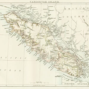
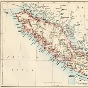
Photo Mug : Vancouver Island map, 1870s


![]()
Home Decor From North Wind
Vancouver Island map, 1870s
Map of Vancouver Island, British Columbia, Canada, 1870s.
Lithograph reproduction of a 19th-century illustration
North Wind Picture Archives brings history to life with stock images and hand-colored illustrations
Media ID 5879572
© North Wind Picture Archives
1870s 1880s British Columbia Canada Canadian Island Pacific Pacific Coast Pacific Northwest Pacific Ocean Strait Juan De Fuca Strait Puget Sound Vancouver Vancouver Island
Photo Mug
Discover the charm of history with our Media Storehouse Photo Mugs featuring a vintage map of Vancouver Island from the 1870s. This exquisite design, sourced from the North Wind Picture Archives, showcases a captivating lithograph reproduction of a 19th-century illustration. Each mug holds a piece of history in your hands, making it a perfect gift for history enthusiasts, collectors, or anyone who appreciates the beauty of the past. Enjoy your favorite beverage while admiring the intricate details of this Vancouver Island map, transporting you back in time.
A personalised photo mug blends sentimentality with functionality, making an ideal gift for cherished loved ones, close friends, or valued colleagues. Preview may show both sides of the same mug.
Elevate your coffee or tea experience with our premium white ceramic mug. Its wide, comfortable handle makes drinking easy, and you can rely on it to be both microwave and dishwasher safe. Sold in single units, preview may show both sides of the same mug so you can see how the picture wraps around.
Mug Size is 8.1cm high x 9.6cm diameter (3.2" x 3.8")
These are individually made so all sizes are approximate
FEATURES IN THESE COLLECTIONS
> North Wind Picture Archives
> Canadian history
> North Wind Picture Archives
> Maps
> Arts
> Artists
> O
> Oceanic Oceanic
> Maps and Charts
> Related Images
> North America
> Canada
> Maps
> North America
> Canada
> Related Images
> North America
> Canada
> Vancouver
> Popular Themes
> North Island
EDITORS COMMENTS
This lithograph reproduction takes us back to the 1870s, offering a glimpse into the rich history and heritage of Vancouver Island, British Columbia. The vintage map showcases the island's intricate details with remarkable precision and artistry. As we explore this piece of traditional artwork, our eyes are immediately drawn to the majestic Pacific Ocean that surrounds Vancouver Island. The map highlights its strategic location along the Pacific Coast, nestled between Juan de Fuca Strait and Puget Sound. The illustration beautifully captures the essence of this Canadian gem, depicting its lush landscapes, charming towns, and bustling ports. It serves as a testament to the island's significance during this era when it was rapidly developing as an important hub in North America. Every stroke on this historic map tells a story – from early settlements to indigenous territories – providing us with invaluable insights into how Vancouver Island evolved over time. This print is not just a visual delight; it is also an educational tool that allows us to delve deeper into Canada's past. Whether you are an art enthusiast or a history buff, this exquisite 19th-century lithograph offers a window into bygone days. It invites you on a journey through time while celebrating the natural beauty and cultural heritage of Vancouver Island – truly capturing its spirit for generations to come.
MADE IN AUSTRALIA
Safe Shipping with 30 Day Money Back Guarantee
FREE PERSONALISATION*
We are proud to offer a range of customisation features including Personalised Captions, Color Filters and Picture Zoom Tools
SECURE PAYMENTS
We happily accept a wide range of payment options so you can pay for the things you need in the way that is most convenient for you
* Options may vary by product and licensing agreement. Zoomed Pictures can be adjusted in the Basket.