Photographic Print > Europe > Macedonia > Maps
Photographic Print : Map Growth Macedonia Rule Philip II Of Macedon


![]()
Photo Prints from Design Pics
Map Growth Macedonia Rule Philip II Of Macedon
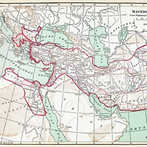
Map showing the growth of Macedonia under the rule of Philip II of Macedon, 382 - 336 BC. From the book Outline of History by H.G. Wells, published 1920
Design Pics offers Distinctively Different Imagery representing over 1,500 contributors
Media ID 32815093
© Ken Welsh
Cartography Chart Countries Geographical Geography Growth Macedonia Rule Philip Ii Of Macedon
10"x8" (25x20cm) Photo Print
"Discover the rich historical depth of ancient Macedonia with our stunning photographic print, "Map Growth Macedonia Rule Philip II Of Macedon" by Ken Welsh from Design Pics. This captivating image illustrates the expansion of Macedonia under the brilliant rule of Philip II (382-336 BC). Based on a map from H.G. Wells' "Outline of History," this print is a must-have for history enthusiasts and those seeking to adorn their walls with a touch of the past. Bring the stories of ancient civilizations to life in your home or office with this exquisite and thought-provoking piece."
Ideal for framing, Australian made Photo Prints are produced on high-quality 270 gsm lustre photo paper which has a subtle shimmer adding a touch of elegance, designed to enhance their visual appeal.
Our Photo Prints are in a large range of sizes and are printed on Archival Quality Paper for excellent colour reproduction and longevity. They are ideal for framing (our Framed Prints use these) at a reasonable cost. Alternatives include cheaper Poster Prints and higher quality Fine Art Paper, the choice of which is largely dependant on your budget.
Estimated Product Size is 20.3cm x 25.4cm (8" x 10")
These are individually made so all sizes are approximate
Artwork printed orientated as per the preview above, with portrait (vertical) orientation to match the source image.
FEATURES IN THESE COLLECTIONS
> Europe
> Macedonia
> Posters
> Europe
> Macedonia
> Related Images
> Maps and Charts
> Early Maps
> Maps and Charts
> North Macedonia
> Maps and Charts
> Related Images
EDITORS COMMENTS
This print showcases the historical significance of Macedonia's growth under the rule of Philip II of Macedon, spanning from 382 to 336 BC. The intricate map, extracted from H. G. Wells' renowned book "Outline of History" published in 1920, offers a fascinating glimpse into the cartography and geography of that era. Engraved with meticulous detail, this archival piece serves as a valuable historical artifact. It vividly illustrates the expansion and territorial conquests achieved by Philip II during his reign. Each country is meticulously charted, providing an invaluable resource for historians and enthusiasts alike. The vintage aesthetic adds a touch of nostalgia to this period picture, transporting us back in time to witness Macedonia's transformation under Philip II's rule. As we gaze upon this illustration, we are reminded of the immense influence and power wielded by ancient civilizations. Ken Welsh has skillfully captured the essence of this historical gem through his photography expertise. This print not only preserves our collective heritage but also invites us to delve deeper into the rich tapestry woven by past civilizations. Whether displayed in educational institutions or private collections dedicated to history aficionados, this remarkable image sparks curiosity about ancient times while paying homage to one man's indelible mark on Macedonian history - Philip II of Macedon.
MADE IN AUSTRALIA
Safe Shipping with 30 Day Money Back Guarantee
FREE PERSONALISATION*
We are proud to offer a range of customisation features including Personalised Captions, Color Filters and Picture Zoom Tools
SECURE PAYMENTS
We happily accept a wide range of payment options so you can pay for the things you need in the way that is most convenient for you
* Options may vary by product and licensing agreement. Zoomed Pictures can be adjusted in the Cart.