Photographic Print > Europe > United Kingdom > Wales > Maps
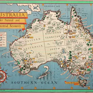
Photographic Print : Maps / Australia 1854


![]()
Photo Prints from Mary Evans Picture Library
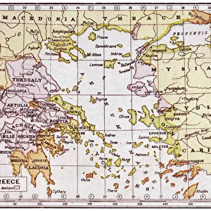
Maps / Australia 1854
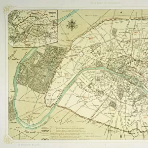
Victoria, New South Wales, South Australia
Mary Evans Picture Library makes available wonderful images created for people to enjoy over the centuries
Media ID 571758
© Mary Evans Picture Library 2015 - https://copyrighthub.org/s0/hub1/creation/maryevans/MaryEvansPictureID/10004467
10"x8" (25x20cm) Photo Print
Discover the rich history of Australia with our exquisite "Maps / Australia 1854" print from the Media Storehouse collection, brought to you by Mary Evans Picture Library from Mary Evans Prints Online. This captivating photograph showcases an intricately detailed map of Victoria, New South Wales, and South Australia from 1854. Travel back in time and explore the historical landscape, as this vintage map provides a fascinating glimpse into the development of Australia during its early colonial era. Add this beautiful, high-quality print to your home or office decor and let the stories of the past unfold before your eyes.
Ideal for framing, Australian made Photo Prints are produced on high-quality 270 gsm lustre photo paper which has a subtle shimmer adding a touch of elegance, designed to enhance their visual appeal.
Our Photo Prints are in a large range of sizes and are printed on Archival Quality Paper for excellent colour reproduction and longevity. They are ideal for framing (our Framed Prints use these) at a reasonable cost. Alternatives include cheaper Poster Prints and higher quality Fine Art Paper, the choice of which is largely dependant on your budget.
Estimated Image Size (if not cropped) is 25.4cm x 18.7cm (10" x 7.4")
Estimated Product Size is 25.4cm x 20.3cm (10" x 8")
These are individually made so all sizes are approximate
Artwork printed orientated as per the preview above, with landscape (horizontal) orientation to match the source image.
FEATURES IN THESE COLLECTIONS
> Mary Evans Prints Online
> Maps
> Europe
> United Kingdom
> Wales
> Maps
> Europe
> United Kingdom
> Wales
> Posters
> Europe
> United Kingdom
> Wales
> Related Images
> Maps and Charts
> Early Maps
> Maps and Charts
> Related Images
> Maps and Charts
> Wales
> Oceania
> Australia
> Related Images
EDITORS COMMENTS
This stunning print captures a piece of history with detailed maps of Australia from 1854. The intricate borders and labels showcase the regions of Victoria, New South Wales, and South Australia during this significant time period. Each line on the map tells a story of exploration, colonization, and growth in these Australian territories.
The rich colors and fine details in this print bring to life the vast landscapes and diverse topography that make up these states. From the rugged coastlines to the sprawling plains, every inch of land is meticulously depicted in this historical document.
As we gaze upon these maps from over a century ago, we are transported back in time to an era when Australia was still being discovered and settled by European explorers. The names of towns and cities may have changed since then, but the essence of each region remains preserved in these beautifully crafted illustrations.
Whether you have a personal connection to Australia or simply appreciate its unique history, this print is sure to captivate your imagination and spark your curiosity about the past. Display it proudly in your home or office as a reminder of how far this great nation has come since 1854.
MADE IN AUSTRALIA
Safe Shipping with 30 Day Money Back Guarantee
FREE PERSONALISATION*
We are proud to offer a range of customisation features including Personalised Captions, Color Filters and Picture Zoom Tools
SECURE PAYMENTS
We happily accept a wide range of payment options so you can pay for the things you need in the way that is most convenient for you
* Options may vary by product and licensing agreement. Zoomed Pictures can be adjusted in the Cart.