Photographic Print > Asia > Lebanon > Maps
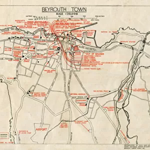
Photographic Print : WW2 - Map of Beirut, Lebanon - with Military locations


![]()
Photo Prints From Mary Evans Picture Library
WW2 - Map of Beirut, Lebanon - with Military locations
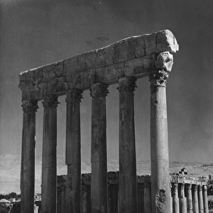
End of WW2 - Map of Beirut, Lebanon showing Military locations important for a British serviceman stationed in the city at the end of the Second World War. The reverse of the map lists the Dos and Don ts whilst on leave in the city! Date: 1945
Mary Evans Picture Library makes available wonderful images created for people to enjoy over the centuries
Media ID 14391078
© Mary Evans / Pharcide
1945 Airport Beirut Beyrouth Chart Cinema Clubs Hostel Lebanese Lebanon Locations Plan
10"x8" (25x20cm) Photo Print
Discover the rich history of the past with our exclusive "WW2 - Map of Beirut, Lebanon - with Military Locations" print from Media Storehouse. This captivating image, sourced from Mary Evans Prints Online and available under Rights Managed licensing, offers a unique glimpse into the end of World War II. For the military historian or history enthusiast, this map provides essential information about key military locations in Beirut, Lebanon, that would have been crucial for a British serviceman stationed in the city during that time. The intricate details of the map transport you back to the era, allowing you to immerse yourself in the stories and events that shaped our history. Add this historic print to your collection and bring a piece of the past into your home or office. Perfect for framing and display, this print not only serves as a beautiful decorative piece, but also as an educational and thought-provoking conversation starter. Order your "WW2 - Map of Beirut, Lebanon - with Military Locations" print today and join us in exploring the fascinating world of history.
Ideal for framing, Australian made Photo Prints are produced on high-quality 270 gsm lustre photo paper which has a subtle shimmer adding a touch of elegance, designed to enhance their visual appeal.
Our Photo Prints are in a large range of sizes and are printed on Archival Quality Paper for excellent colour reproduction and longevity. They are ideal for framing (our Framed Prints use these) at a reasonable cost. Alternatives include cheaper Poster Prints and higher quality Fine Art Paper, the choice of which is largely dependant on your budget.
Estimated Product Size is 25.4cm x 20.3cm (10" x 8")
These are individually made so all sizes are approximate
Artwork printed orientated as per the preview above, with landscape (horizontal) orientation to match the source image.
FEATURES IN THESE COLLECTIONS
> Asia
> Lebanon
> Related Images
> Historic
> World War I and II
> World War II
> Maps and Charts
> Related Images
> Maps and Charts
> World
EDITORS COMMENTS
This vintage map of Beirut, Lebanon, dates back to the end of World War II in 1945. The map provides an intriguing glimpse into the city as it appeared during that historical period, with a specific focus on military locations that would have been of particular importance to a British serviceman stationed in the area. The map is rich in detail, highlighting various military installations, barracks, and camps scattered throughout the city. These included the British Military Headquarters located near the Martyrs' Square, the Royal Army Ordnance Corps Depot in Ras Beirut, and the Royal Navy Base at the Beirut Waterfront. On the reverse side of the map, a list of "Dos and Don'ts" is provided for the serviceman on his leave in the city. The "Dos" include recommendations to visit popular clubs and cinemas such as the American Club, the British Club, and the Riviera Cinema. The "Don'ts," on the other hand, caution against visiting certain areas of the city, particularly those with a high crime rate or known to be off-limits to Allied personnel. The map also includes various other points of interest, such as hotels, hostels, and the Beirut International Airport. The Lebanese capital was a bustling hub of activity during the post-war period, and this map offers a fascinating insight into the city's military and social landscape at that time. This map is a valuable historical document, providing a unique perspective on Beirut during the waning days of World War II and the early days of the peace that followed. It is a reminder of the rich history and cultural diversity of this fascinating city and the role it played in world events during that era.
MADE IN AUSTRALIA
Safe Shipping with 30 Day Money Back Guarantee
FREE PERSONALISATION*
We are proud to offer a range of customisation features including Personalised Captions, Color Filters and Picture Zoom Tools
SECURE PAYMENTS
We happily accept a wide range of payment options so you can pay for the things you need in the way that is most convenient for you
* Options may vary by product and licensing agreement. Zoomed Pictures can be adjusted in the Basket.