Photographic Print > Animals > Insects > Hemiptera > Hall Scale
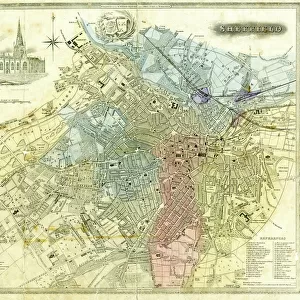
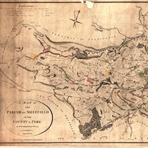
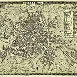
Photographic Print : A correct plan of the town of Sheffield by William Fairbank, 1771


![]()
Photo Prints from Sheffield City Archives
A correct plan of the town of Sheffield by William Fairbank, 1771
Scale 440 yards : 3.3 inches.
Shows the Bull Stake, slaughterhouses, Town Mill, Irish Cross.
Original at Local Studies y09647
Sheffield City Archives and Local Studies Library has an unrivalled collection of images of Sheffield, England
Media ID 14048645
© Sheffield City Council
Bridge Castle Chapel Company Corn Croft Cutlers Fairbank Hall Hill King Lane Little Maps Mill Mills Moor Norfolk Power River Rivers Sheffield Spring Square Street Tilt Waingate Walk Water Waterwheels Wheel Wicker Yorkshire Alley Alsop Brighouse Change Cheney Colson Crofts Dixon Folds Jehu Ladys Mulberry Newhall Orchard Pepper Pudding Simon
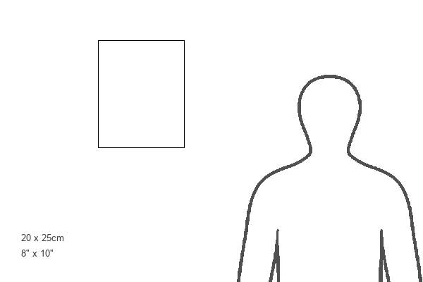
10"x8" (25x20cm) Photo Print
Discover the rich history of Sheffield with our exquisite Media Storehouse Photographic Prints. This captivating piece showcases an authentic 1771 plan of the town of Sheffield, meticulously drawn by William Fairbank. Delve into the past as you explore the Bull Stake, slaughterhouses, Town Mill, and Irish Cross, all depicted with remarkable detail. Each print is produced using high-quality materials, ensuring vibrant colors and long-lasting durability. Bring a piece of Sheffield's history into your home or office and add a unique touch to your decor. Authenticity guaranteed, as each print is based on the original held at the Sheffield City Archives (Local Studies y09647).
Ideal for framing, Australian made Photo Prints are produced on high-quality 270 gsm lustre photo paper which has a subtle shimmer adding a touch of elegance, designed to enhance their visual appeal.
Our Photo Prints are in a large range of sizes and are printed on Archival Quality Paper for excellent colour reproduction and longevity. They are ideal for framing (our Framed Prints use these) at a reasonable cost. Alternatives include cheaper Poster Prints and higher quality Fine Art Paper, the choice of which is largely dependant on your budget.
Estimated Product Size is 20.3cm x 25.4cm (8" x 10")
These are individually made so all sizes are approximate
Artwork printed orientated as per the preview above, with portrait (vertical) orientation to match the source image.
FEATURES IN THESE COLLECTIONS
> Animals
> Insects
> Hemiptera
> Hall Scale
> Arts
> Artists
> I
> William Ireland
> Europe
> Republic of Ireland
> Maps
> Europe
> United Kingdom
> England
> Norfolk
> Related Images
> Europe
> United Kingdom
> England
> Norfolk
> Mill Street
> Europe
> United Kingdom
> England
> Yorkshire
> Old Town
> Europe
> United Kingdom
> England
> Yorkshire
> Related Images
> Europe
> United Kingdom
> England
> Yorkshire
> Sheffield
> Europe
> United Kingdom
> England
> Yorkshire
> Street
> Europe
> United Kingdom
> England
> Yorkshire
> Woodlands
> Sheffield City Archives
> Maps and Plans
> Maps of Sheffield
EDITORS COMMENTS
This print showcases a historically significant map titled "A correct plan of the town of Sheffield" by William Fairbank, dating back to 1771. The intricate details and precision of this map offer a glimpse into the past, providing valuable insights into the layout and features of Sheffield during that era. The scale of 440 yards to 3.3 inches allows for a comprehensive view, highlighting notable landmarks such as the Bull Stake, slaughterhouses, Town Mill, and Irish Cross. These elements serve as reminders of Sheffield's rich industrial heritage. The original copy can be found at Local Studies y09647 in the esteemed Sheffield City Archives. This remarkable piece combines various elements like maps, wicker structures, tilt mechanisms, waterwheels powered by flowing water from Simon Wheel Woodlands Castle Orchard. As we explore further within this image's frame, we encounter familiar street names such as Dixon Lane Folds Waingate Pudding Brighouse King Pond Mill Union Cheney Square Pepper Alley Norfolk Chapel Walk Change Mulberry Jehu Ladys Bridge Irish Cross Newhall Colson Crofts Spring Croft Cutlers Hall Old Company River Don Rivers Corn Mills Alsop Fields Little Moor Yorkshire Fairbank). It is important to note that this photograph should not be used for commercial purposes; rather it serves as an invaluable resource for historical research and preservation.
MADE IN AUSTRALIA
Safe Shipping with 30 Day Money Back Guarantee
FREE PERSONALISATION*
We are proud to offer a range of customisation features including Personalised Captions, Color Filters and Picture Zoom Tools
SECURE PAYMENTS
We happily accept a wide range of payment options so you can pay for the things you need in the way that is most convenient for you
* Options may vary by product and licensing agreement. Zoomed Pictures can be adjusted in the Cart.