Poster Print > Europe > United Kingdom > England > Maps
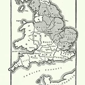
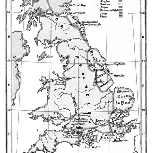
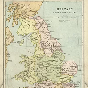
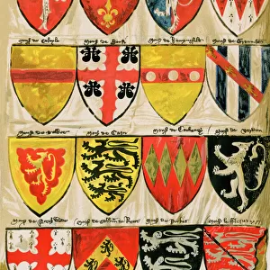
Poster Print : Antique map of Britain under the Anglo Saxons

![]()
Poster Prints From Fine Art Storehouse
Antique map of Britain under the Anglo Saxons
Unleash your creativity and transform your space into a visual masterpiece!
duncan1890
Media ID 14549471
© This content is subject to copyright
1870s Ancient Civilisation Ancient History Bad Condition British Colour Colours Condition English Equipment Faded Great Britain Image Created 1870 1879 Medieval Middle Ages Navigational Equipment Northern Europe Retro Saxon Styles Supplies Traditional United Kingdom
A4 (29.7 x 21cm) Poster Print
Discover the rich history of Britain under the Anglo Saxons with our stunning Antique Map of Britain print from the Media Storehouse collection, exclusively available at Fine Art Storehouse. This captivating piece, created by the talented artist duncan1890, transports you back in time to an era of ancient kingdoms and legendary tales. The intricate details of this vintage map reveal the territories and borders of the Anglo Saxon kingdoms, making it a must-have for history enthusiasts and art lovers alike. Bring a piece of the past into your home or office with this beautiful and authentic-looking antique map print. Order now and let the stories of Britain's past come alive in your space.
Premium quality poster prints are printed on luxurious semi-gloss satin 270 gsm paper. Our meticulously crafted poster prints offer an affordable option for decorating any space, making them ideal for living rooms, bedrooms, offices and beyond. To ensure your poster arrives in good condition, we roll and send them in strong mailing tubes.
Poster prints are budget friendly enlarged prints in standard poster paper sizes (A0, A1, A2, A3 etc). Whilst poster paper is sometimes thinner and less durable than our other paper types, they are still ok for framing and should last many years. Our Archival Quality Photo Prints and Fine Art Paper Prints are printed on higher quality paper and the choice of which largely depends on your budget.
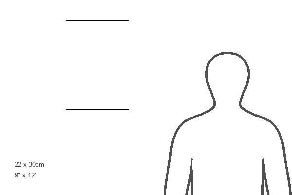
Estimated Product Size is 21.6cm x 30.3cm (8.5" x 11.9")
These are individually made so all sizes are approximate
Artwork printed orientated as per the preview above, with landscape (horizontal) or portrait (vertical) orientation to match the source image.
FEATURES IN THESE COLLECTIONS
> Fine Art Storehouse
> Map
> Historical Maps
> Fine Art Storehouse
> Top Sellers - Art Prints
> Arts
> Art Movements
> Medieval Art
> Europe
> United Kingdom
> England
> Maps
> Europe
> United Kingdom
> England
> Paintings
> Historic
> Historical fashion trends
> Medieval fashion trends
> Maps and Charts
> Early Maps
> Maps and Charts
> Related Images
> Popular Themes
> Maps and Charts
EDITORS COMMENTS
This print takes us back in time to the ancient civilization of Britain under the rule of the Anglo Saxons. Created in the 1870s, this antique map showcases a remarkable piece of history with its intricate details and faded colors. Despite its bad condition, it exudes an undeniable charm that transports us to a bygone era. The engraving skillfully depicts the geographical landscape of Great Britain during medieval times, offering a glimpse into how navigational equipment was utilized during that period. The illustration and painting techniques employed in this image showcase traditional styles prevalent in 19th-century cartography. As we explore this vintage artwork, we can't help but appreciate the meticulous craftsmanship involved in creating such maps before modern technology took over. It serves as a reminder of our rich heritage and allows us to connect with our ancestors who once roamed these lands. Though worn by time, this print evokes a sense of nostalgia and curiosity about England's past. It invites us to delve deeper into British history and discover more about the fascinating Anglo Saxon era. Duncan1890 has preserved an important piece of European history through this lithograph, ensuring that future generations can admire and learn from it. This print is not just an old-fashioned relic; it is a window into our collective past – one that deserves appreciation for its cultural significance.
MADE IN AUSTRALIA
Safe Shipping with 30 Day Money Back Guarantee
FREE PERSONALISATION*
We are proud to offer a range of customisation features including Personalised Captions, Color Filters and Picture Zoom Tools
SECURE PAYMENTS
We happily accept a wide range of payment options so you can pay for the things you need in the way that is most convenient for you
* Options may vary by product and licensing agreement. Zoomed Pictures can be adjusted in the Basket.