Fraud Blocker Skip to main content

Home > Design Pics > Vintage Maps

Vintage Maps Collection (#5)

507 Items

We are proud to offer this selection in partnership with Design Pics

Background imageVintage Maps Collection: Betsiboka River, Madagascar, True Colour Satellite Image. Betsiboka river

Betsiboka River, Madagascar, True Colour Satellite Image. Betsiboka river, the major river of Madagascar, goes into the Mozambique canal, close to the city of Mahajanga

Background imageVintage Maps Collection: Bissagos Archipelago, Guinea-Bissau, True Colour Satellite Image

Bissagos Archipelago, Guinea-Bissau, True Colour Satellite Image. True colour satellite image of Guinea-Bissau, a small country in West Africa

Background imageVintage Maps Collection: Western Europe At Night, Satellite Image. Lights of Western Europe at night from space. Coloured ima

Western Europe At Night, Satellite Image. Lights of Western Europe at night from space. Coloured image derived from satellite data showing Western Europe at night

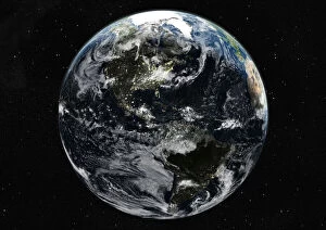
Background imageVintage Maps Collection: Globe Centred On The Americas, True Colour Satellite Image. True colour satellite image of

Globe Centred On The Americas, True Colour Satellite Image. True colour satellite image of the Earth centred on the Americas with cloud coverage, during summer solstice at 6 a.m GMT

Background imageVintage Maps Collection: Libyan Desert, Egypt, True Colour Satellite Image. True colour satellite image of the Egyptian

Libyan Desert, Egypt, True Colour Satellite Image. True colour satellite image of the Egyptian part of the Libyan desert, made of both sand and rock; sand dunes are stretched out by the winds

Background imageVintage Maps Collection: Globe Africa, True Colour Satellite Image. Earth. True colour satellite image of the Earth, centred

Globe Africa, True Colour Satellite Image. Earth. True colour satellite image of the Earth, centred on Africa. North is at top

Background imageVintage Maps Collection: Globe Showing Asia, True Colour Satellite Image Of The Earth Showing Asia, Oceania And The Sun

Globe Showing Asia, True Colour Satellite Image Of The Earth Showing Asia, Oceania And The Sun
Globe Showing Asia, True Colour Satellite Image. True colour satellite image of the Earth showing Asia and Oceania, half in shadow, and the sun

Background imageVintage Maps Collection: Globe Showing Northern America, True Colour Satellite Image Of The Earth

Globe Showing Northern America, True Colour Satellite Image Of The Earth
Globe Showing Northern America, True Colour Satellite Image. True colour satellite image of the Earth showing Greenland, the North Pole and Northern America

Background imageVintage Maps Collection: Globe Showing The Americas, True Colour Satellite Image Of The Earth, Half In Shadow And The Sun

Globe Showing The Americas, True Colour Satellite Image Of The Earth, Half In Shadow And The Sun
Globe Showing The Americas, True Colour Satellite Image. True colour satellite image of the Earth showing the Americas, half in shadow, and the sun

Background imageVintage Maps Collection: Globe Showing Europe And Northern Africa, True Colour Satellite Image Of The Earth

Globe Showing Europe And Northern Africa, True Colour Satellite Image Of The Earth
Globe Showing Europe And Northern Africa, True Colour Satellite Image. True colour satellite image of the Earth showing Europe and Northern Africa, with cloud coverage

Background imageVintage Maps Collection: Globe Centred On The South Pole, True Colour Satellite Image Of The Earth

Globe Centred On The South Pole, True Colour Satellite Image Of The Earth
Globe Centred On The South Pole, True Colour Satellite Image. True colour satellite image of the Earth centred on the South Pole with cloud coverage, during summer solstice at 12 a.m GMT

Background imageVintage Maps Collection: Globe Centred On Asia And Oceania, True Colour Satellite Image Of The Earth

Globe Centred On Asia And Oceania, True Colour Satellite Image Of The Earth
Globe Centred On Asia And Oceania, True Colour Satellite Image. True colour satellite image of the Earth centred on Asia and Oceania with cloud coverage, during summer solstice at 6 a.m GMT

Background imageVintage Maps Collection: Globe Showing Europe, True Colour Satellite Image Of The Earth Showing Greenland, North Pole, Europe

Globe Showing Europe, True Colour Satellite Image Of The Earth Showing Greenland, North Pole, Europe
Globe Showing Europe, True Colour Satellite Image. True colour satellite image of the Earth showing Greenland, the North Pole and Europe, with cloud coverage

Background imageVintage Maps Collection: North America At Night, True Colour Satellite Image. True colour satellite image of North America

North America At Night, True Colour Satellite Image. True colour satellite image of North America at night. This image in Lambert Conformal Conic projection was compiled from data acquired by LANDSAT

Background imageVintage Maps Collection: Whole Earth At Night With Cloud Coverage, True Colour Satellite Image

Whole Earth At Night With Cloud Coverage, True Colour Satellite Image. True colour satellite image of the whole Earth at night with cloud coverage

Background imageVintage Maps Collection: Everglades, Florida, Usa, True Colour Satellite Image. Satellite image of the Everglades

Everglades, Florida, Usa, True Colour Satellite Image. Satellite image of the Everglades. At the top of the image is the edge of the city of Miami

Background imageVintage Maps Collection: Rub Al Khali Desert, Saudi Arabia, True Colour Satellite Image. Rub Al Khali

Rub Al Khali Desert, Saudi Arabia, True Colour Satellite Image. Rub Al Khali, a sand desert South East of Saudi Arabia; sand dunes are sculptured and moved by the winds

Background imageVintage Maps Collection: Simpson Desert, Australia, True Colour Satellite Image. True colour satellite image of the Simpson

Simpson Desert, Australia, True Colour Satellite Image. True colour satellite image of the Simpson Desert in the Australian Outback. The sand dunes are coloured in red because of iron oxyd

Background imageVintage Maps Collection: Mississippi River Delta, Louisiana, Usa, True Colour Satellite Image

Mississippi River Delta, Louisiana, Usa, True Colour Satellite Image. True colour satellite image of the Mississippi River Delta

Background imageVintage Maps Collection: Agriculture, Texas, Usa, True Colour Satellite Image. True colour satellite image of center-pivot

Agriculture, Texas, Usa, True Colour Satellite Image. True colour satellite image of center-pivot irrigated fields in Texas, USA. Image taken on 21 September 1993 using LANDSAT data

Background imageVintage Maps Collection: Globe North Pole, True Colour Satellite Image. Cloudless true colour satellite image of the Earth, c

Globe North Pole, True Colour Satellite Image. Cloudless true colour satellite image of the Earth, centred on the Arctic or north polar region

Background imageVintage Maps Collection: Globe North America, True Colour Satellite Image. Earth. True colour satellite image of the Earth, c

Globe North America, True Colour Satellite Image. Earth. True colour satellite image of the Earth, centred on North America. The North Pole is at upper centre

Background imageVintage Maps Collection: Globe showing the Americas

Globe showing the Americas
Globe With Dark Background Showing The Americas

Background imageVintage Maps Collection: Map Of Ancient Alexandria, Egypt. From The Imperial Bible Dictionary, Published 1889

Map Of Ancient Alexandria, Egypt. From The Imperial Bible Dictionary, Published 1889

Background imageVintage Maps Collection: Map Showing The Coalfields Of Great Britain In The 19th Century

Map Showing The Coalfields Of Great Britain In The 19th Century. From The National Encyclopaedia, Published C. 1890
Map Showing The Coalfields Of Great Britain In The 19th Century. From The National Encyclopaedia, Published C.1890

Background imageVintage Maps Collection: Map Showing French Territory Held By The English When Jeanne D arc Appeared, 1429

Map Showing French Territory Held By The English When Jeanne D arc Appeared, 1429. Illustrated Easy Stories From English History

Background imageVintage Maps Collection: Map Showing The English Dominions In France At The Time Of The Treaty Of Br

Map Showing The English Dominions In France At The Time Of The Treaty Of Br

Background imageVintage Maps Collection: Map Showing The French Dominions Of Henry Ii. Illustrated Easy Stories From English History

Map Showing The French Dominions Of Henry Ii. Illustrated Easy Stories From English History

Background imageVintage Maps Collection: Plan Of Ephesus, The Ancient Greek City And Its Environs, The Sites As Named By Edward Falkener C

Plan Of Ephesus, The Ancient Greek City And Its Environs, The Sites As Named By Edward Falkener C. 1842. From The Imperial Bible Dictionary, Published 1889

Background imageVintage Maps Collection: Map Of Athens And Piraeus, Greece, Mid 19th Century. From The Imperial Bible Dictionary

Map Of Athens And Piraeus, Greece, Mid 19th Century. From The Imperial Bible Dictionary, Published 1889

Background imageVintage Maps Collection: Map Showing The Battle Of Atbara During The Second Sudan War Also Called The Mahdist War

Map Showing The Battle Of Atbara During The Second Sudan War Also Called The Mahdist War, The Mahdist Revolt, Anglo-Sudan War Or The Sudanese Mahdist Revolt, 1898

Background imageVintage Maps Collection: Lord Kitcheners Blockhouse System In South Africa. The Ramifications Of The Blockhouse System

Lord Kitcheners Blockhouse System In South Africa. The Ramifications Of The Blockhouse System, Which Played So Large A Part In The Concluding Operations In South Africa, After The Second Boer War

Background imageVintage Maps Collection: Fragment Of The Turgot Map Of Paris, France, Showing La Porte Saint-Antoine

Fragment Of The Turgot Map Of Paris, France, Showing La Porte Saint-Antoine, The Great Entrance To The East Of Paris That Defended The Bastille. From A Contemporary Print

Background imageVintage Maps Collection: Plan Of Alexandria, Egypt At The Turn Of The 20Th Century. Map Is Edited In Spanish Language

Plan Of Alexandria, Egypt At The Turn Of The 20Th Century. Map Is Edited In Spanish Language. From Enciclopedia Ilustrada Segu

Background imageVintage Maps Collection: Plan Of Amsterdam, Holland, At The Turn Of The 20Th Century. Map Is Edited In Spanish Language

Plan Of Amsterdam, Holland, At The Turn Of The 20Th Century. Map Is Edited In Spanish Language. From Enciclopedia Ilustrada Segu

Background imageVintage Maps Collection: Granada, Spain. Plan Of The Alhambra And Surrounding Districts Around The Turn Of The 20Th Century

Granada, Spain. Plan Of The Alhambra And Surrounding Districts Around The Turn Of The 20Th Century. From Enciclopedia Ilustrada Segu

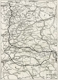
Background imageVintage Maps Collection: Map Of The Somme Offensive On The Western Front During World War One. From The Year 1916 Illustrated

Map Of The Somme Offensive On The Western Front During World War One. From The Year 1916 Illustrated

Background imageVintage Maps Collection: Chart Showing The Course Of The British Fleet In The Battle Of Jutland Bank During World War I

Chart Showing The Course Of The British Fleet In The Battle Of Jutland Bank During World War I. From The Year 1916 Illustrated

Background imageVintage Maps Collection: Plan Of Olympia, Elis, Greece. Site Of The Olympic Games In Classical Times

Plan Of Olympia, Elis, Greece. Site Of The Olympic Games In Classical Times. From A History Of Greece, Published 1920

Background imageVintage Maps Collection: Map To King Solomons Mines, Extrapolated From The Original In Allan Quartermains Possession Which

Map To King Solomons Mines, Extrapolated From The Original In Allan Quartermains Possession Which Had Been Drawn In His Own Blood By Dom Jose Da Silvestra In 1590. From King Solomons Mines By H

Background imageVintage Maps Collection: Map To King Solomons Mines. From King Solomons Mines By H. Rider Haggard, Published London, 1886

Map To King Solomons Mines. From King Solomons Mines By H. Rider Haggard, Published London, 1886. Caption Says, Facsimile Of The Map Of Route To King Solomons Mines

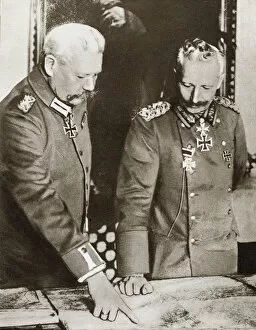
Background imageVintage Maps Collection: Kaiser Wilhelm Ii (Left) And Field Marshal Von Hindenburg Studying Maps During The First World War

Kaiser Wilhelm Ii (Left) And Field Marshal Von Hindenburg Studying Maps During The First World War. From The Story Of 25 Eventful Years In Pictures, Published 1935

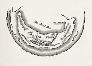
Background imageVintage Maps Collection: A Map Of Africa As Depicted During The 8Th Century Bc. From In Darkest Africa By Henry M

A Map Of Africa As Depicted During The 8Th Century Bc. From In Darkest Africa By Henry M. Stanley Published 1890

Background imageVintage Maps Collection: Map Of The Nile Basin In 1819 Ad. From In Darkest Africa By Henry M. Stanley Published 1890

Map Of The Nile Basin In 1819 Ad. From In Darkest Africa By Henry M. Stanley Published 1890

Background imageVintage Maps Collection: Map Of Western Canada Including The Five Great Lakes, Circa 1760

Map Of Western Canada Including The Five Great Lakes, Circa 1760. From Atlas De Toutes Les Parties Connues Du Globe Terrestre By Cartographer Rigobert Bonne Published Geneva Circa 1760

Background imageVintage Maps Collection: Madagascar And Comoros Islands Circa 1760. From Atlas De Toutes Les Parties Connues Du Globe

Madagascar And Comoros Islands Circa 1760. From Atlas De Toutes Les Parties Connues Du Globe Terrestre By Cartographer Rigobert Bonne Published Geneva Circa 1760

Background imageVintage Maps Collection: Australia Circa 1760. Mercator Projection. From Atlas De Toutes Les Parties Connues Du Globe

Australia Circa 1760. Mercator Projection. From Atlas De Toutes Les Parties Connues Du Globe Terrestre By Cartographer Rigobert Bonne Published Geneva Circa 1760

Background imageVintage Maps Collection: Australia Circa 1760. From Atlas De Toutes Les Parties Connues Du Globe Terrestre By Cartographer

Australia Circa 1760. From Atlas De Toutes Les Parties Connues Du Globe Terrestre By Cartographer Rigobert Bonne Published Geneva Circa 1760


All Professionally Made to Order for Quick Shipping


-

Why Choose Us?

We are a leading provider of Art Prints and Photo Gifts since 2003, working in partnership with a range of Sporting Clubs, Charities, Museums and Picture Libraries. A large share of profits from any of their images will go directly towards supporting that charity or club. Our archive of images is carefully curated to bring you a wide range of subjects, including landscapes, wildlife, architecture, and more. We ship from our partner labs in the UK, USA, EU (Netherlands) and Australia.
+

How do I place an order?

Ordering is quick & easy - Just follow 5 Simple Steps:
  1. Find your image: Use our search box or browse our online photo Collections to find the image you want.

  2. Choose your print format: Select your desired product and add it to your cart.

  3. Enter your details: If you're a returning customer, simply enter your email address and password, and we'll fill in your billing and shipping address details. All personal details are held securely and are fully GDPR compliant. As standard, we remove all Personally Identifiable Information after 12 months.

  4. Pay for your purchase: We use state-of-the-art security for online shopping and do not have access to your card details.

  5. Sit back and relax: We'll email you confirmation of your order and when it's dispatched. Registered customers can also track orders in the 'My Account' area.

+

How do I pay for an order?

You can pay for your order with most of the major credit and debit cards, or PayPal. For added security, major financial institutions process payment details separately and securely on our behalf. We do not have access to your online payment card details. Online payments are preferred however we do take phone orders. For UK customers only we accept cheques issued against a UK bank.
+

Is my data safe?

We take data security very seriously. We do not have access to your full card details and all payments are requested over a fully secure connection. Additionally, we fully comply with current European and GDPR legislation, and automatically remove all personal data after at most 12 months (unless you have an account with us and have signed in recently). We also have a strict opt-in policy and would never sell your personal details. Your data is only used to fulfill your order promptly and efficiently.
+

Is wall art ready to hang?

For quick and easy installation all wall art, including framed prints, canvas prints and metal prints are supplied with a ready to hang solution on the back. Generally, saw tooth hangers are applied as they allow wall art to hang flush against the wall. The serrated edge of the hanger prevents the frame from shifting or tilting when hung.
+

Are the photo prints fade resistant?

Yes, we use archival quality photo paper photographic paper for vivid reproduction Prints are an accurate representations of the original artwork, which is preserved for artistic character and authenticity. We guarantee they match previews shown on our web site