Metal Print > Aerial Photography > Africa
Metal Print : Earth, topographic and bathymetric map


![]()
Metal Prints from Science Photo Library
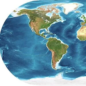
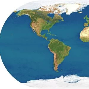
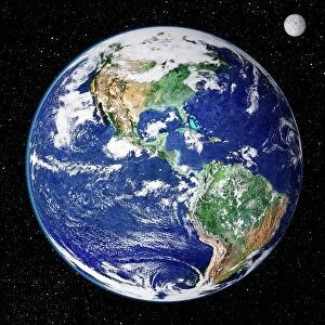
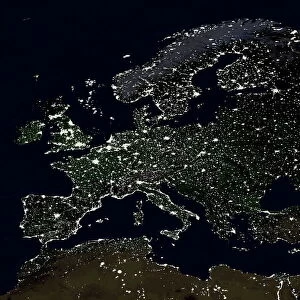
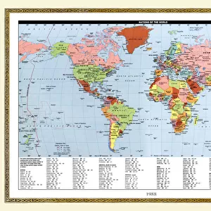
Earth, topographic and bathymetric map
Earth. Blue Marble: Next Generation cloud-free topographic and bathymetric map of the Earth in July 2004. Highlands and lowlands of the continents are shown as ridges and flat areas, with Arctic and Antarctic ice in white. The seabed depth varies from shallow (light blue) on the continental shelves, to deep ocean basins (dark blue). Topographic and bathymetric data is usually gathered by using aerial and satellite imagery combined with radar and sonar mapping. Landcover data is from NASAs Moderate Resolution Imaging Spectroradiometer (MODIS) sensor aboard the Terra satellite
Science Photo Library features Science and Medical images including photos and illustrations
Media ID 6328989
© NASA/SCIENCE PHOTO LIBRARY
Africa Altimetric Altimetry Bathymetric Bathymetry Blue Marble Composite Continent Continental Shelf Continents Depth Earth Observation Flat Projection From Space Global Height Highlands Land Lowlands Mapped Modis Mountains Nasa Next Generation Oceanic Oceanographic Oceanography Pacific Ocean Physical Geography Plains Radar Ridge Satellite Satellite Image Sea Bed Sea Floor Shelves Sonar Mapping Terra Topographic Topography Whole Earth World
14"x11" (28x35cm) Metal Print
Our Metal Prints feature rounded corners and rear fixings for easy wall mounting. Images are directly printed onto a lightweight, high quality 5mm thick, durable metallic surface for a vivid and vibrant finish. Available in 2 sizes, 28x35cm (14x11) and 50x40cm (20x16). The unique material is fade, moisture, chemical and scratch resistant to help ensure this art lasts a lifetime.
Made with durable metal and luxurious printing techniques, metal prints bring images to life and add a modern touch to any space
Estimated Product Size is 35.5cm x 27.9cm (14" x 11")
These are individually made so all sizes are approximate
Artwork printed orientated as per the preview above, with landscape (horizontal) or portrait (vertical) orientation to match the source image.
FEATURES IN THESE COLLECTIONS
> Aerial Photography
> Related Images
> Animals
> Mammals
> Muridae
> Plains Mouse
> Arts
> Artists
> O
> Oceanic Oceanic
> Europe
> France
> Canton
> Landes
> Europe
> United Kingdom
> Scotland
> Highlands
> Related Images
> Maps and Charts
> Flat Earth
> Maps and Charts
> Related Images
> Maps and Charts
> World
> Science Photo Library
> Aerial and Satellite
MADE IN AUSTRALIA
Safe Shipping with 30 Day Money Back Guarantee
FREE PERSONALISATION*
We are proud to offer a range of customisation features including Personalised Captions, Color Filters and Picture Zoom Tools
SECURE PAYMENTS
We happily accept a wide range of payment options so you can pay for the things you need in the way that is most convenient for you
* Options may vary by product and licensing agreement. Zoomed Pictures can be adjusted in the Cart.