
Maps Collection
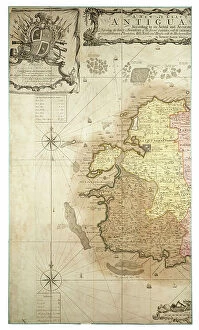
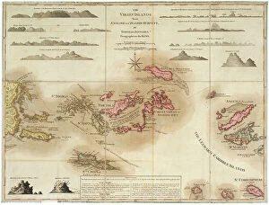
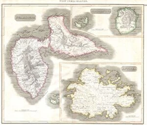
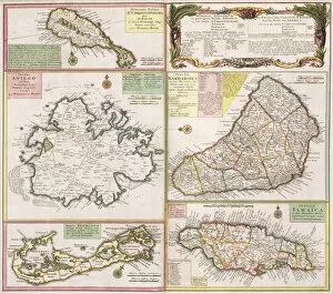
Maps of Antigua and Barbuda North America are a collection that provide detailed information about the two Caribbean islands
Choose a picture from our collection for your Wall Art and Photo Gifts
30 Items


All Professionally Made to Order for Quick Shipping
-
Maps Collection
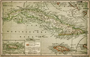
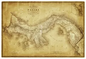
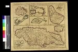
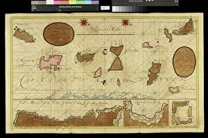
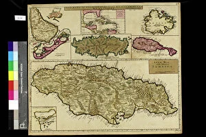
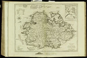
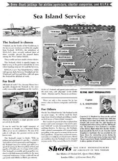
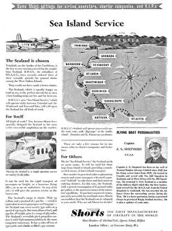
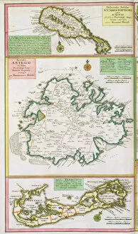
Maps of Antigua and Barbuda North America are a collection that provide detailed information about the two Caribbean islands. The maps show the location of each island, as well as their physical features such as rivers, mountains, and beaches. They also include information on population density, transportation networks, and political boundaries. Additionally, they feature points of interest such as historical sites and national parks. They can available in both digital and printed formats so that users can find what they need quickly and easily. With these detailed maps at hand, travelers can easily plan their trips to Antigua and Barbuda with confidence.
+
Our beautiful Wall Art and Photo Gifts include Framed Prints, Photo Prints, Poster Prints, Canvas Prints, Jigsaw Puzzles, Metal Prints and so much more
The Maps of Antigua and Barbuda North America collection is a stunning assortment of vintage maps that showcase the beauty and history of these two Caribbean islands. Available through Media Storehouse, our collection features high-quality wall art and framed prints that are perfect for adding a touch of elegance to any home space. Each map in our collection offers a unique glimpse into the geography, topography, and culture of Antigua and Barbuda. From detailed depictions of local landmarks to colorful illustrations highlighting important historical events, these maps provide an immersive experience that transports viewers back in time. Whether you're looking to decorate your living room with a beautiful antique map or add some character to your workspace with a vibrant print, the Maps of Antigua and Barbuda North America collection has something for everyone. So why not explore this fascinating corner of the world today?
+
What are Maps of Antigua and Barbuda North America art prints?
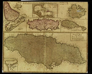
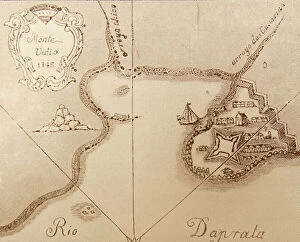
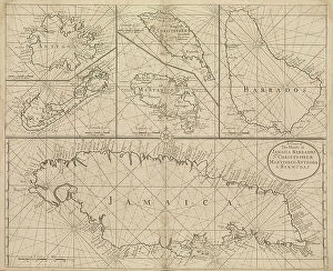
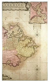
Maps of Antigua and Barbuda North America art prints are high-quality reproductions of antique maps depicting the islands of Antigua and Barbuda in the Caribbean region. These maps were originally created by cartographers during the 17th, 18th, and 19th centuries as a means to navigate through these territories. The Maps of Antigua and Barbuda North America art prints showcase intricate details such as coastlines, rivers, mountains, settlements, forts, and other landmarks that were significant at the time. They also feature decorative elements like compass roses, ornate borders with illustrations of sea creatures or mythological figures. These art prints serve not only as historical documents but also as beautiful pieces of wall decor for homes or offices. They can be framed or mounted on canvas to suit individual preferences. Whether you're an avid collector or simply appreciate fine art with a touch of history, Maps of Antigua and Barbuda North America art prints are sure to impress.
+
What Maps of Antigua and Barbuda North America art prints can I buy from Media Storehouse?
We offer a wide range of Maps of Antigua and Barbuda North America art prints that you can buy. These maps are perfect for those who love history, geography or simply want to decorate their homes with unique artwork. The collection includes antique maps, vintage posters, and modern illustrations that showcase the beauty of these two islands. You can choose from various styles and sizes to suit your preferences. Some popular options include detailed topographical maps that show the terrain and landscape features of Antigua and Barbuda, as well as colorful illustrated maps that highlight the cultural landmarks and attractions on both islands. Whether you're looking for a gift for someone special or want to add some character to your living space, we have something for everyone. With high-quality printing techniques and premium materials used in each print, you can be sure that your purchase will last a lifetime.
+
How do I buy Maps of Antigua and Barbuda North America art prints?
To buy maps of Antigua and Barbuda North America art prints from Media Storehouse, you can browse our extensive collection of high-quality images on their website. Once you have found the print that you like, simply add it to your cart and proceed to checkout. You will be prompted to enter your shipping information and payment details. We offer a variety of sizes and framing options for their prints, so be sure to select the one that best fits your needs. We also offer a range of other products such as canvas prints, posters, and greeting cards featuring the same artwork. If you have any questions or concerns about purchasing from Media Storehouse, they have a helpful customer service team available to assist you. Buying maps of Antigua and Barbuda North America art prints from Media Storehouse is an easy process that allows you to bring beautiful artwork into your home or office.
+
How much do Maps of Antigua and Barbuda North America art prints cost?
The cost of Maps of Antigua and Barbuda North America art prints varies depending on the size and type of print selected. The price range is affordable for most budgets, making it easy to find a suitable option that fits your needs. These maps are perfect for anyone who loves geography or wants to decorate their home with unique artwork. They showcase the beauty and diversity of Antigua and Barbuda in an artistic way that will enhance any room's decor. Whether you're looking for a small print or a large one, there are plenty of options available at reasonable prices. So if you want to add some character to your living space, consider purchasing one of these beautiful maps from Media Storehouse today.
+
How will my Maps of Antigua and Barbuda North America art prints be delivered to me?
Your Maps of Antigua and Barbuda North America art prints will be delivered to you in a safe and secure manner. Media Storehouse takes great care in packaging your artwork to ensure it arrives at your doorstep undamaged. The prints are carefully rolled and placed into sturdy cardboard tubes, which are then sealed with protective caps on both ends. Once packaged, the tube is shipped directly to your address using a reliable courier service. You can track the delivery status of your order through our website or by contacting our customer support team. We understand that receiving your artwork promptly is important, so we strive to dispatch orders as quickly as possible once payment has been received. Rest assured that we take every measure necessary to ensure that you receive high-quality art prints in perfect condition. Your Maps of Antigua and Barbuda North America art prints will be delivered safely and securely via a trusted courier service in protective cardboard tubes.